
File:Karte Deutsch-Dänischer Krieg Gebietsveränderungen.svg

Size of this PNG preview of this SVG file: 501 × 600 pixels. Other resolutions: 200 × 240 pixels | 401 × 480 pixels | 641 × 768 pixels | 855 × 1,024 pixels | 1,710 × 2,048 pixels | 1,860 × 2,227 pixels.
Original file (SVG file, nominally 1,860 × 2,227 pixels, file size: 696 KB)
| This is a file from the Wikimedia Commons. Information from its description page there is shown below. Commons is a freely licensed media file repository. You can help. |
| Description |
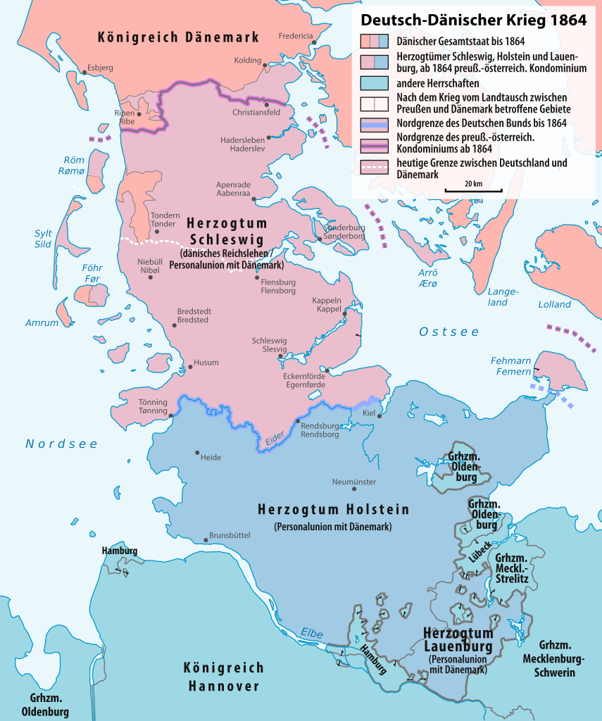
Deutsch: Karte der Grenzänderungen durch den Deutsch-Dänischen Krieg
English: Map of the boundary changes after the Second Schleswig War |
| Date | see file history |
| Source |
Own work, using |
| Author | Maximilian Dörrbecker (Chumwa) |
| Permission (Reusing this file) |
I, the copyright holder of this work, hereby publish it under the following license: This file is licensed under the Creative Commons Attribution-Share Alike 3.0 Unported license.
Sie dürfen das Bild zu den folgenden Bedingungen nutzen:
|

|
This map has been made or improved in the German Kartenwerkstatt (Map Lab). You can propose maps to improve as well.
|
File history
Click on a date/time to view the file as it appeared at that time.
| Date/Time | Thumbnail | Dimensions | User | Comment | |
|---|---|---|---|---|---|
| current | 13:25, 24 December 2016 | | 1,860 × 2,227 (696 KB) | Chumwa | |
| 15:53, 23 December 2016 |  | 1,860 × 2,227 (689 KB) | Chumwa | ||
| 21:42, 25 July 2016 |  | 1,860 × 2,227 (674 KB) | Chumwa | Schleswig gehörte nicht zum Deutschen Bund | |
| 18:15, 29 May 2015 |  | 1,860 × 2,227 (668 KB) | Chumwa | Sonderborg-Sønderburg -> Sonderburg-Sønderborg | |
| 12:10, 23 May 2015 |  | 1,860 × 2,227 (668 KB) | Chumwa | Typos | |
| 10:53, 23 May 2015 |  | 1,860 × 2,227 (669 KB) | Chumwa | Schleswig mit eigener Farbe | |
| 07:39, 23 May 2015 |  | 1,860 × 2,227 (647 KB) | Chumwa | Mini-Korrekturen | |
| 15:57, 22 May 2015 |  | 1,860 × 2,227 (657 KB) | Chumwa | Fehmarn; Austauschgebiete | |
| 18:03, 21 May 2015 |  | 1,860 × 2,227 (657 KB) | Chumwa | {{Information |Description= {{de|Karte der Grenzänderungen durch den Deutsch-Dänischen Krieg}} {{en|Map of the boundary changes after the Second Schleswig War}} |Source={{Own}}, using * [... |
File usage
The following pages on the English Wikipedia use this file (pages on other projects are not listed):
Global file usage
The following other wikis use this file:
- Usage on cs.wikipedia.org
- Usage on da.wikipedia.org
- Usage on de.wikipedia.org
- 1864
- Herzogtum Schleswig
- Gasteiner Konvention
- Herzogtum Holstein
- Frieden von Wien (1864)
- Königliche Enklaven
- Elbherzogtümer
- Deutsch-Dänischer Krieg
- Wahlrecht in den deutschen Einzelstaaten bis 1918
- Wikipedia:Kartenwerkstatt/Archiv/2015-05
- Mission Gablenz
- Österreichisch-preußisches Kondominium in Schleswig-Holstein
- Usage on fr.wikipedia.org
- Usage on nl.wikipedia.org
- Usage on no.wikipedia.org
- Usage on ru.wikipedia.org
- Usage on sv.wikipedia.org
- Usage on uz.wikipedia.org
- Usage on zh.wikipedia.org