
File:Karta PG Woodlark isl.png
No higher resolution available.
Karta_PG_Woodlark_isl.png (300 × 200 pixels, file size: 5 KB, MIME type: image/png)
| This is a file from the Wikimedia Commons. Information from its description page there is shown below. Commons is a freely licensed media file repository. You can help. |
Summary
| Description |
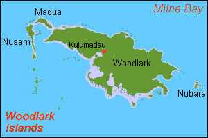
English: Map (rough) Woodlark islands, Papua New Guinea, own work composed from various mapreferences |
| Date | |
| Source | Own work |
| Author | Hobe / Holger Behr |
Licensing
| I, the copyright holder of this work, release this work into the public domain. This applies worldwide. In some countries this may not be legally possible; if so: I grant anyone the right to use this work for any purpose, without any conditions, unless such conditions are required by law. |
File history
Click on a date/time to view the file as it appeared at that time.
| Date/Time | Thumbnail | Dimensions | User | Comment | |
|---|---|---|---|---|---|
| current | 12:26, 30 September 2007 | | 300 × 200 (5 KB) | Hobe | {{Information |Description=map woodlark islands, Papua New Guinea |Source=self-made, composed from various mapreferences |Date=2007-09-30 |Author= Hobe Category:Maps of Papua New Guinea }} |
File usage
The following pages on the English Wikipedia use this file (pages on other projects are not listed):
Global file usage
The following other wikis use this file:
- Usage on als.wikipedia.org
- Usage on de.wikipedia.org
- Usage on es.wikipedia.org
- Usage on fr.wikipedia.org
- Usage on he.wikipedia.org
- Usage on it.wikipedia.org
- Usage on ka.wikipedia.org
- Usage on nl.wikipedia.org
- Usage on pl.wikipedia.org
- Usage on pnb.wikipedia.org
- Usage on ru.wikipedia.org
- Usage on sv.wikipedia.org
- Usage on www.wikidata.org
- Usage on zh.wikipedia.org