
File:Karpathos OnEarth WMS.png

Size of this preview: 187 × 599 pixels. Other resolutions: 75 × 240 pixels | 150 × 480 pixels | 797 × 2,553 pixels.
Original file (797 × 2,553 pixels, file size: 2.21 MB, MIME type: image/png)
| This is a file from the Wikimedia Commons. Information from its description page there is shown below. Commons is a freely licensed media file repository. You can help. |
| This image is in the public domain because it is a screenshot from NASA’s globe software World Wind using a public domain layer, such as Blue Marble, MODIS, Landsat, SRTM, USGS or GLOBE.
|
 |
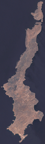
Satellite image of
- English: Karpathos
- Ελληνικά: Κάρπαθος
Image taken from NASA World Wind, OnEarth WMS global mosaic visual layer.
File history
Click on a date/time to view the file as it appeared at that time.
| Date/Time | Thumbnail | Dimensions | User | Comment | |
|---|---|---|---|---|---|
| current | 13:01, 23 September 2006 | 797 × 2,553 (2.21 MB) | Hautala | {{PD-WorldWind}} Satellite image of * {{en|Karpathos}} * {{el|Κάρπαθος}} Image taken from NASA World Wind, OnEarth WMS global mosaic visual layer. Category:Karpathos Category:Satellite pictures of Greece |
File usage
The following pages on the English Wikipedia use this file (pages on other projects are not listed):
Global file usage
The following other wikis use this file:
- Usage on ab.wikipedia.org
- Usage on ar.wikipedia.org
- Usage on be.wikipedia.org
- Usage on bg.wikipedia.org
- Usage on de.wikipedia.org
- Usage on fi.wikipedia.org
- Usage on hy.wikipedia.org
- Usage on it.wikipedia.org
- Usage on ru.wikipedia.org
- Usage on sv.wikipedia.org
- Usage on zh.wikipedia.org