
File:Kalalau-trail.JPG

Size of this preview: 800 × 185 pixels. Other resolutions: 320 × 74 pixels | 640 × 148 pixels | 1,024 × 237 pixels | 4,326 × 1,000 pixels.
Original file (4,326 × 1,000 pixels, file size: 3.73 MB, MIME type: image/jpeg)
| This is a file from the Wikimedia Commons. Information from its description page there is shown below. Commons is a freely licensed media file repository. You can help. |
Summary
| Description |
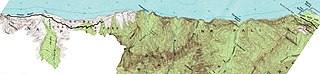
English: USGS Topographical Chart, HAENA, HAWAII, N2207--W15932.5 / 7.5; edited left edge of image to show Kalalau Valley below 600 feet elevation; also edited right edge of image to show the end of the paved road as a thick black line |
| Date | |
| Source | http://store.usgs.gov |
| Author | United States of American (USA), Department of Interior, United States Geological Survey (USGS) |
| Permission (Reusing this file) |
Public Domain because it is a work of the United States Federal Government, See http://www.usgs.gov/laws/info_policies.html |
Licensing
This image is in the public domain in the United States because it only contains materials that originally came from the United States Geological Survey, an agency of the United States Department of the Interior. For more information, see the official USGS copyright policy.
|
File history
Click on a date/time to view the file as it appeared at that time.
| Date/Time | Thumbnail | Dimensions | User | Comment | |
|---|---|---|---|---|---|
| current | 16:05, 7 November 2009 | 4,326 × 1,000 (3.73 MB) | W>Citizen-of-wiki | improved edit of image | |
| 05:01, 7 November 2009 | 4,326 × 1,000 (3.86 MB) | W>Citizen-of-wiki | Improved edit of image file | ||
| 21:57, 31 October 2009 | 4,323 × 739 (1.21 MB) | W>Citizen-of-wiki | {{Information |Description = USGS Topographical Chart, HAENA, HAWAII, N2207--W15932.5 / 7.5; edited left edge of image to show Kalalau Valley below 600 feet elevation; also edited right edge of image to show the end of the paved road as a thick black |
File usage
The following pages on the English Wikipedia use this file (pages on other projects are not listed):