
File:Junction fault 0112.jpg

Size of this preview: 800 × 600 pixels. Other resolutions: 320 × 240 pixels | 640 × 480 pixels | 1,024 × 768 pixels | 1,280 × 960 pixels | 2,560 × 1,920 pixels.
Original file (2,560 × 1,920 pixels, file size: 3.88 MB, MIME type: image/jpeg)
| This is a file from the Wikimedia Commons. Information from its description page there is shown below. Commons is a freely licensed media file repository. You can help. |
Summary
| Description |
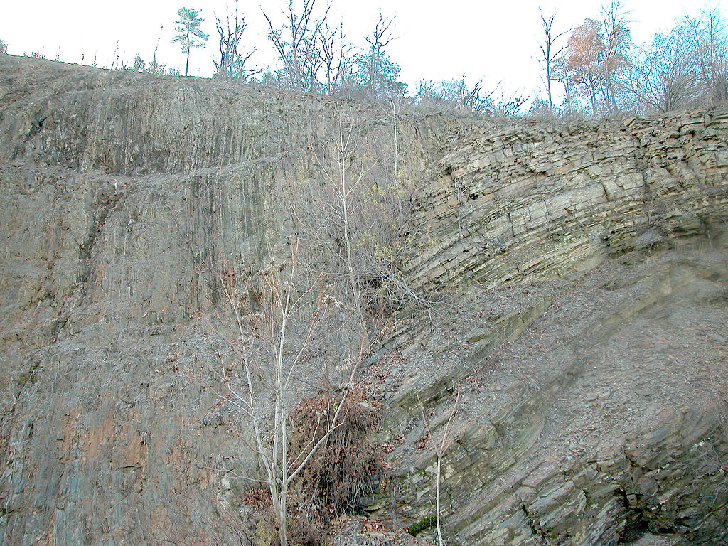
English: Dividing fault between Appalachian Mountains and Allegheny Plateau. A major geologic fault (directly behind small trees) can be seen in a new roadcut about 6 miles north of en:Williamsport, Pennsylvania on new Route 15. The fault is just about at the line that divides the folded en:Appalachian Mountains and the merely uplifted en:dissected plateau of the en:Allegheny Plateau. On the left hand (south side) is metamorphic rock. On the right hand is en:sedimentary rock, which, as one continues northward becomes mostly horizontal.
Image copyleft: Image taken by me, released under GFDL, Pollinator 06:08, Dec 25, 2004 (UTC) |
| Date | 25 December 2004 (original upload date) |
| Source | Transferred from en.wikipedia to Commons. |
| Author | Pollinator at English Wikipedia |
| Camera location | | View this and other nearby images on: OpenStreetMap |
|---|
Licensing
| This file is licensed under the Creative Commons Attribution-Share Alike 3.0 Unported license. Subject to disclaimers. | ||
| ||
| This licensing tag was added to this file as part of the GFDL licensing update. |

|
Permission is granted to copy, distribute and/or modify this document under the terms of the GNU Free Documentation License, Version 1.2 or any later version published by the Free Software Foundation; with no Invariant Sections, no Front-Cover Texts, and no Back-Cover Texts. A copy of the license is included in the section entitled GNU Free Documentation License. Subject to disclaimers. |
Original upload log
The original description page was here. All following user names refer to en.wikipedia.
- 2004-12-25 06:01 Pollinator 2560×1920×8 (4068378 bytes) Dividing fault between Appalachian Mountains and Allegheny Plateau
File history
Click on a date/time to view the file as it appeared at that time.
| Date/Time | Thumbnail | Dimensions | User | Comment | |
|---|---|---|---|---|---|
| current | 10:08, 17 December 2007 | | 2,560 × 1,920 (3.88 MB) | File Upload Bot (Magnus Manske) | {{BotMoveToCommons|en.wikipedia}} {{Information |Description={{en|Dividing fault between Appalachian Mountains and Allegheny Plateau A major geologic fault (directly behind small trees) can be seen in a new roadcut about 10 miles north of [[:en:Williams |
File usage
The following pages on the English Wikipedia use this file (pages on other projects are not listed):
Global file usage
The following other wikis use this file:
- Usage on eo.wikipedia.org
- Usage on es.wikipedia.org
- Usage on fr.wikipedia.org
- Usage on gl.wikipedia.org
- Usage on id.wikipedia.org
- Usage on it.wikipedia.org
- Usage on ja.wikipedia.org
- Usage on sl.wikipedia.org
- Usage on th.wikipedia.org
- Usage on zh.wikipedia.org