
File:Judea and Samaria settlements.gif

Size of this preview: 302 × 600 pixels. Other resolutions: 121 × 240 pixels | 242 × 480 pixels | 387 × 768 pixels | 515 × 1,024 pixels | 1,515 × 3,008 pixels.
Original file (1,515 × 3,008 pixels, file size: 150 KB, MIME type: image/gif)
| This is a file from the Wikimedia Commons. Information from its description page there is shown below. Commons is a freely licensed media file repository. You can help. |
Summary
| Description |
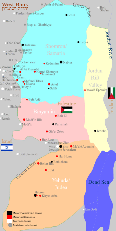
العربية: المستوطنات الإسرائيلية. English: The occupied West Bank, or "Judea and Samaria" – with its four main geographic sub-regions each with its cluster of Israeli settlements interspersed among the Palestinian Arab towns and villages: Shomron, Binyamin, Yehuda (subdevided in turn to Jerusalem, Gush Etzion, Har Hebron and the Judean Desert) and the Jordan Rift Valley. |
| Date | |
| Source | Created by me fully manually sketched top to bottom using vector tools on a transparent layer placed upon a basic pattern of the border retrieved from common educational resources (of the type available for example here) +B'tzelem 2002 map for locating the settlements. Orrling |
| Author | Orrling |
Licensing
I, the copyright holder of this work, hereby publish it under the following license:
This file is licensed under the Creative Commons Attribution-Share Alike 3.0 Unported license.
- You are free:
- to share – to copy, distribute and transmit the work
- to remix – to adapt the work
- Under the following conditions:
- attribution – You must give appropriate credit, provide a link to the license, and indicate if changes were made. You may do so in any reasonable manner, but not in any way that suggests the licensor endorses you or your use.
- share alike – If you remix, transform, or build upon the material, you must distribute your contributions under the same or compatible license as the original.
File history
Click on a date/time to view the file as it appeared at that time.
| Date/Time | Thumbnail | Dimensions | User | Comment | |
|---|---|---|---|---|---|
| current | 20:37, 29 January 2012 | | 1,515 × 3,008 (150 KB) | Orrling | Numerous small improvements & enhancements |
| 00:51, 29 January 2012 |  | 1,515 × 3,008 (138 KB) | Orrling | Some towns within Israel were omitted in the original work, so I added them + image title. | |
| 21:40, 28 January 2012 |  | 1,505 × 3,008 (123 KB) | Orrling |
File usage
The following pages on the English Wikipedia use this file (pages on other projects are not listed):
Global file usage
The following other wikis use this file:
- Usage on de.wikipedia.org
- Usage on www.wikidata.org