
File:Joseph Canyon Map.gif
No higher resolution available.
Joseph_Canyon_Map.gif (312 × 365 pixels, file size: 25 KB, MIME type: image/gif)
| This is a file from the Wikimedia Commons. Information from its description page there is shown below. Commons is a freely licensed media file repository. You can help. |
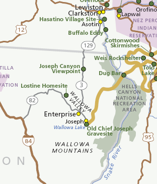
Summary
| Description |
Map of the Nez Perce National Historical Park visitor stop locations, in eastern Oregon and Washington (state).
|
| Source | National Park Service, Nez Perce National Historical Park Map |
| Author | National Park Service |
| Permission (Reusing this file) |
public domain |
Licensing
| This image or media file contains material based on a work of a National Park Service employee, created as part of that person's official duties. As a work of the U.S. federal government, such work is in the public domain in the United States. See the NPS website and NPS copyright policy for more information. |
File history
Click on a date/time to view the file as it appeared at that time.
| Date/Time | Thumbnail | Dimensions | User | Comment | |
|---|---|---|---|---|---|
| current | 09:34, 17 March 2008 | | 312 × 365 (25 KB) | Northwest-historian | {{Information |Description=Detail of the Nez Perce National Historical Park map, showing Joseph Canyon and other sites in the area. |Source=National Park Service, [http://www.nps.gov/nepe/planyourvisit/upload/NEPEmap1.pdf Nez Perce National Historical Par |
File usage
The following pages on the English Wikipedia use this file (pages on other projects are not listed):
Global file usage
The following other wikis use this file:
- Usage on ro.wikipedia.org