
File:Jason-1 measurement system.gif
No higher resolution available.
Jason-1_measurement_system.gif (651 × 527 pixels, file size: 72 KB, MIME type: image/gif)
| This is a file from the Wikimedia Commons. Information from its description page there is shown below. Commons is a freely licensed media file repository. You can help. |
Summary
| Description |
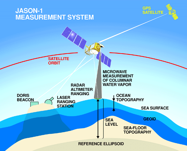
English: Every 10 days, Jason-1 measures the height of more than 90% of the world's ice-free ocean with its radar altimeter and completes 127 revolutions, or orbits, around Earth.
To measure sea surface height it is necessary to know satellite's exact position in its orbit and the distance between the satellite and the ocean's surface. Corrections are made for variable amounts of water vapor in the lower atmosphere and free electrons in the upper atmosphere, which can delay the altimeter's microwave pulses. The sea height caused by gravity (the geoid) is mathematically removed in order to create maps of ocean surface topography. |
| Date | |
| Source | http://sealevel.jpl.nasa.gov/gallery/posters.html |
| Author | NASA/JPL |
Licensing
| This file is in the public domain in the United States because it was solely created by NASA. NASA copyright policy states that "NASA material is not protected by copyright unless noted". (See Template:PD-USGov, NASA copyright policy page or JPL Image Use Policy.) | ||
 |
Warnings:
|
File history
Click on a date/time to view the file as it appeared at that time.
| Date/Time | Thumbnail | Dimensions | User | Comment | |
|---|---|---|---|---|---|
| current | 18:39, 6 October 2008 | | 651 × 527 (72 KB) | Maddox1 | {{Information |Description={{en|1=Every 10 days, Jason-1 measures the height of more than 90% of the world's ice-free ocean with its radar altimeter and completes 127 revolutions, or orbits, around Earth. To measure sea surface height it is necessary to |
File usage
The following pages on the English Wikipedia use this file (pages on other projects are not listed):
Global file usage
The following other wikis use this file:
- Usage on ar.wikipedia.org
- Usage on id.wikipedia.org
- Usage on it.wikipedia.org
- Usage on pt.wikipedia.org
- Usage on ru.wikipedia.org
- Usage on sr.wikipedia.org
- Usage on uk.wikipedia.org