
File:Japan trench topographic.png

Size of this preview: 600 × 600 pixels. Other resolutions: 240 × 240 pixels | 480 × 480 pixels.
Original file (800 × 800 pixels, file size: 221 KB, MIME type: image/png)
| This is a file from the Wikimedia Commons. Information from its description page there is shown below. Commons is a freely licensed media file repository. You can help. |
Summary
| Description |
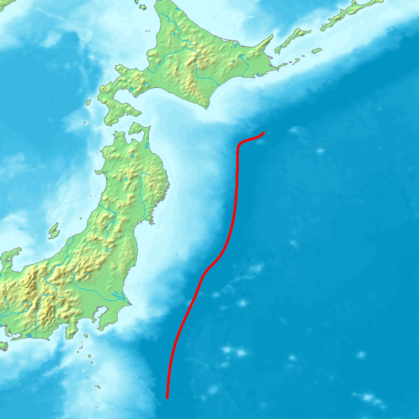
English: Map of northeastern Japan (main islands Honshu and Hokkaido) and the sourrounding seas. The red line marks the course of the axis of the Japan Trench, a deep sea trench off the east coast of Japan, which is a bathymetric expression of the subduction of the Pacific Plate beneath the Eurasian Plate. Its northern extension ist the Kuril Trench.
Deutsch: Karte des nordöstlichen Teils Japans (Hauptinseln Honshu and Hokkaido) und der umliegenden Meere. Die rote Linie markiert des Verlauf der Achse des Japangrabens, einer Tiefseerinne vor der Ostküste Japans, die bathymetrischer Ausdruck der Subduktion der Pazifischen Platte unter die Eurasische Platte ist. Seine nördliche Fortsetzung ist der Kurilengraben. |
| Source | Image:Topographic30deg_N30E120.png, Headquarters for Earthquake Research Promotion homepage |
| Author | Peka |
Licensing

|
Permission is granted to copy, distribute and/or modify this document under the terms of the GNU Free Documentation License, Version 1.2 or any later version published by the Free Software Foundation; with no Invariant Sections, no Front-Cover Texts, and no Back-Cover Texts. A copy of the license is included in the section entitled GNU Free Documentation License. |
| This file is licensed under the Creative Commons Attribution-Share Alike 3.0 Unported license. | ||
| ||
| This licensing tag was added to this file as part of the GFDL licensing update. |
File history
Click on a date/time to view the file as it appeared at that time.
| Date/Time | Thumbnail | Dimensions | User | Comment | |
|---|---|---|---|---|---|
| current | 08:56, 6 October 2007 | | 800 × 800 (221 KB) | Pekachu | {{Information |Description= Map of the Japan Trench(a trench near the east coast of Japan). |Source=Image:Topographic30deg_N30E120.png, [http://www.jishin.go.jp/main/p_hyoka02_kaiko.htm Headquarters for Earthquake Research Promotion homepage] |Date= |
File usage
The following pages on the English Wikipedia use this file (pages on other projects are not listed):
Global file usage
The following other wikis use this file:
- Usage on az.wikipedia.org
- Usage on be.wikipedia.org
- Usage on ca.wikipedia.org
- Usage on de.wikipedia.org
- Usage on es.wikipedia.org
- Usage on fr.wikipedia.org
- Usage on he.wikipedia.org
- Usage on hu.wikipedia.org
- Usage on it.wikipedia.org
- Usage on ja.wikipedia.org
- Usage on kk.wikipedia.org
- Usage on ko.wikipedia.org
- Usage on no.wikipedia.org
- Usage on pl.wikipedia.org
- Usage on pt.wikipedia.org
- Usage on ru.wikipedia.org
- Usage on th.wikipedia.org
- Usage on uk.wikipedia.org
- Usage on vi.wikipedia.org
- Usage on www.wikidata.org
- Usage on zh.wikipedia.org