
File:JadeWeser.png
Size of this preview: 624 × 599 pixels. Other resolutions: 250 × 240 pixels | 500 × 480 pixels | 800 × 768 pixels | 1,066 × 1,024 pixels | 2,133 × 2,048 pixels | 3,365 × 3,231 pixels.
Original file (3,365 × 3,231 pixels, file size: 655 KB, MIME type: image/png)
| This is a file from the Wikimedia Commons. Information from its description page there is shown below. Commons is a freely licensed media file repository. You can help. |
- Diese Karte in 33 %-Projektion (1122 Pixel Fensterbreite bzw. 216 dpi)
- Diese Karte in 50 %-Projektion (1678 Pixel Fensterbreite bzw. 144 dpi)
Summary
| Description |
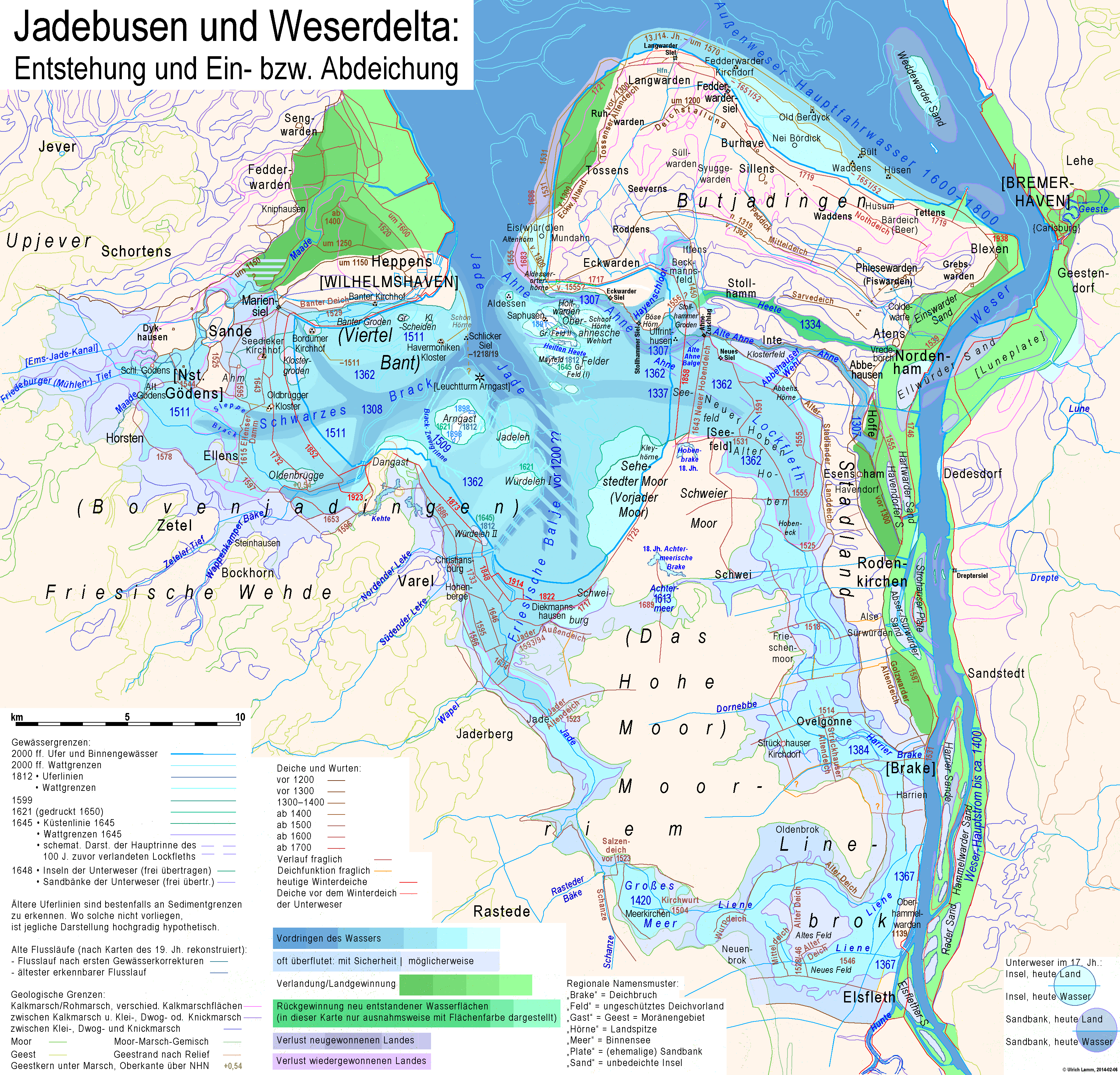
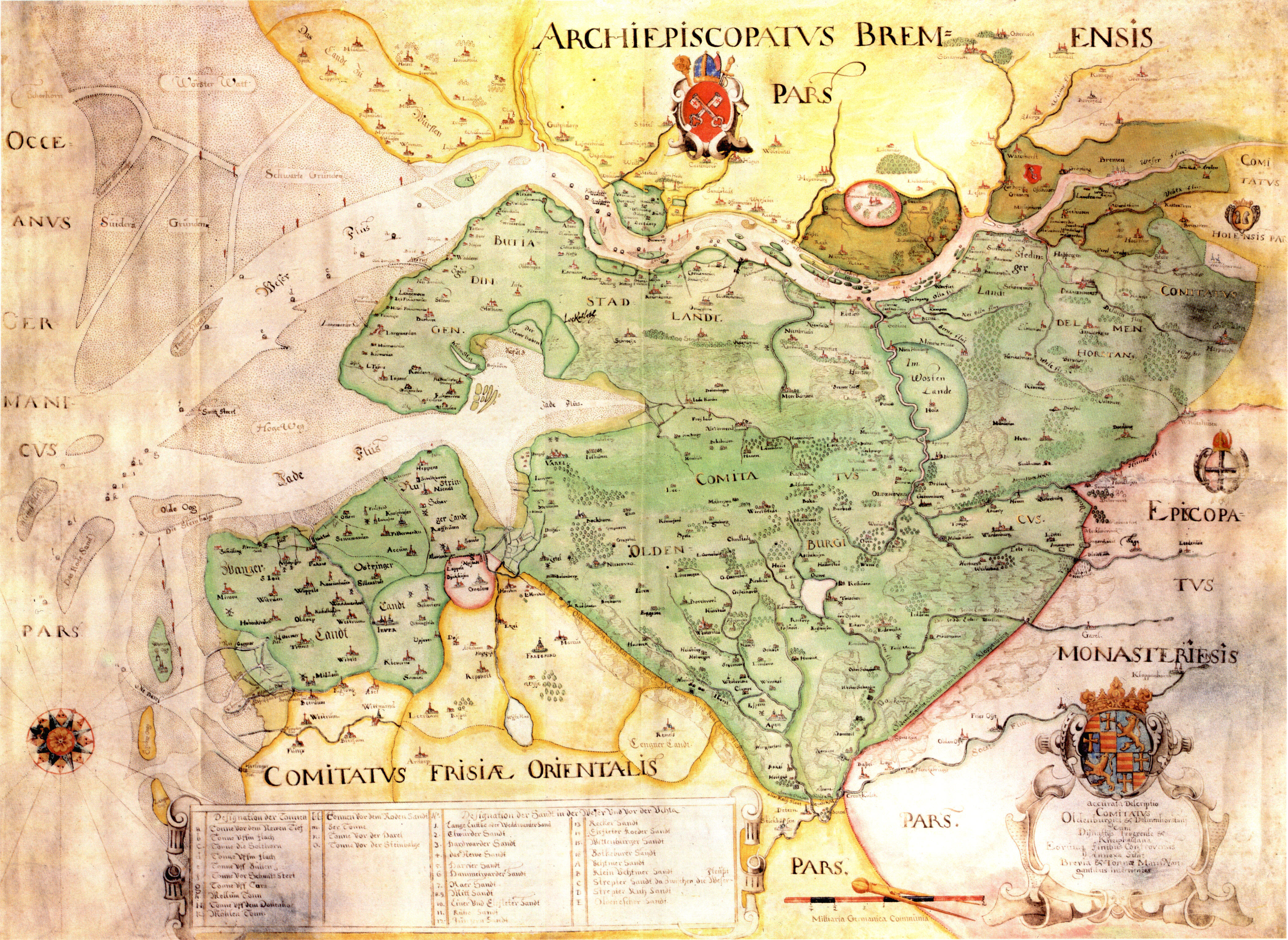
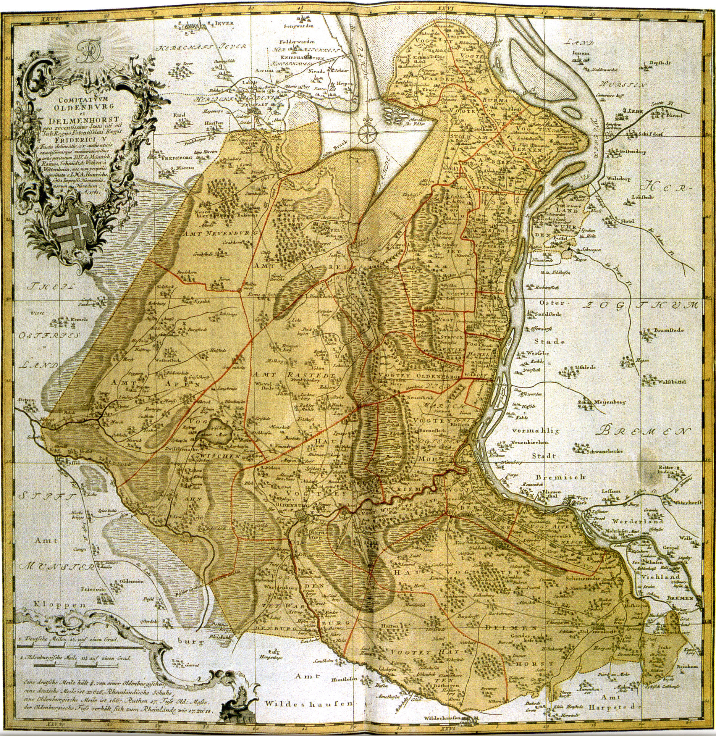
Deutsch: Jadebusen und zeitweiliges Weserdelta: Entstehung und Eindeichung des Jadebusens, Entstehung und Abdeichung der Gewässerarme zwischen Jadebusen und Unterweser, sowie die Verlandung und Abdeichung der Maadebucht sind konsequent mit ihren Zwischenstufen dargestellt. Bei der Unterweser ist die Entwicklung der Winterdeiche und Landgewinnung am linken Ufer in mehreren Stufen dargestellt, die Geschichte von Inseln, Sandbänken und des rechten Ufers dagegen vereinfacht. Hier wurde nur versucht, dem heutigen Zustand eine Darstellung für das 17. Jahrhundert gegenüberzustellen. Für alle Teilgebiete wurden nur dort Konturlinien gezeichnet, wo sie sich aus erhaltenen Strukturen oder Sedimenten oder glaubhaften zeitnahen Kartendarstellungen herleiten lassen. Flächenfarben wurden konsequent für neu entstandene Wasserflächen und für die Verlandung „ursprünglicher“ Wasserflächen verwendet. Auf die Farbmarkierung der Rückgewinnung seit etwa 1200 verlorener Landflächen wurde größtenteils verzichtet. English: Development of the Jadebusen (Jade Bight) and the interim delta of Weser river• blue areas = advancement of waterbodies • green areas = growth of land • grayish pale blue areas = sometimes flooded • grayish lilac areas = newly gained land lost again • grayish pink areas = regained land lost again • brown to red lines = dikes • bold intensive light blue line = today's coastline • light blue lines = today's forshore limit • bold pale blue lines = forshore limit c. 1810 • dirty lilac lines = foreshore limit c. 1645 • light pink to light lilac, ocre and light green lines = geological soil borders. Areal colours are uesd almost only for new won land. Regaining of losses mostly is marked only by the dikes. Nederlands: Ontstaan van het Jadeboezem en de tijdelijke delta van de Wezer |
| Date | |
| Source | Own work |
| Author | Ulamm (talk) 16:15, 6 February 2014 (UTC) |
| Other versions |
• Diese Karte, jedoch mit farblicher Betonung der Situationen kurz vor und nach 1362 This map with reduced colour chart, situations short before and after 1362 emphasized |
Sources of research
- Karl-Ernst Behre: Die Geschichte der Landschaft um den Jadebusen, Brune-Mettker GmbH, Wilhelmshaven 2012, ISBN 978-3-941929-02-9
- Topografische Karte 1:100 000 C 2714 Bremerhaven und Nachbarblätter.
- Geodatenzentrum Hannover → Bodenkunde → Bodenübersichtskarte 1:50 000
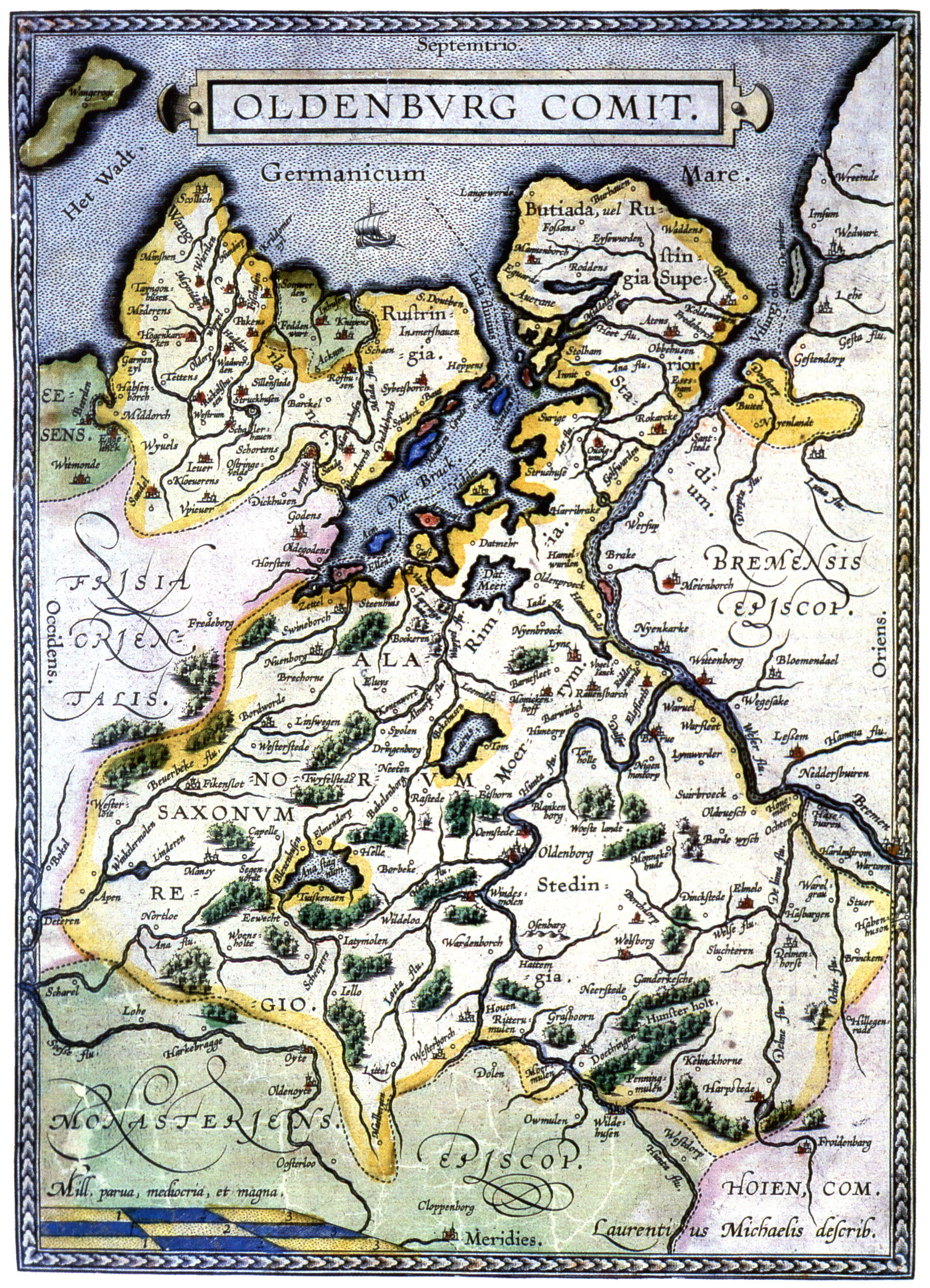
- Michaelis Laurentius: Grafschaft Oldenburg (1579/1584), teilweise stark verzerrt
- Karten der Grafschaft Oldenburg: 17. Jh.
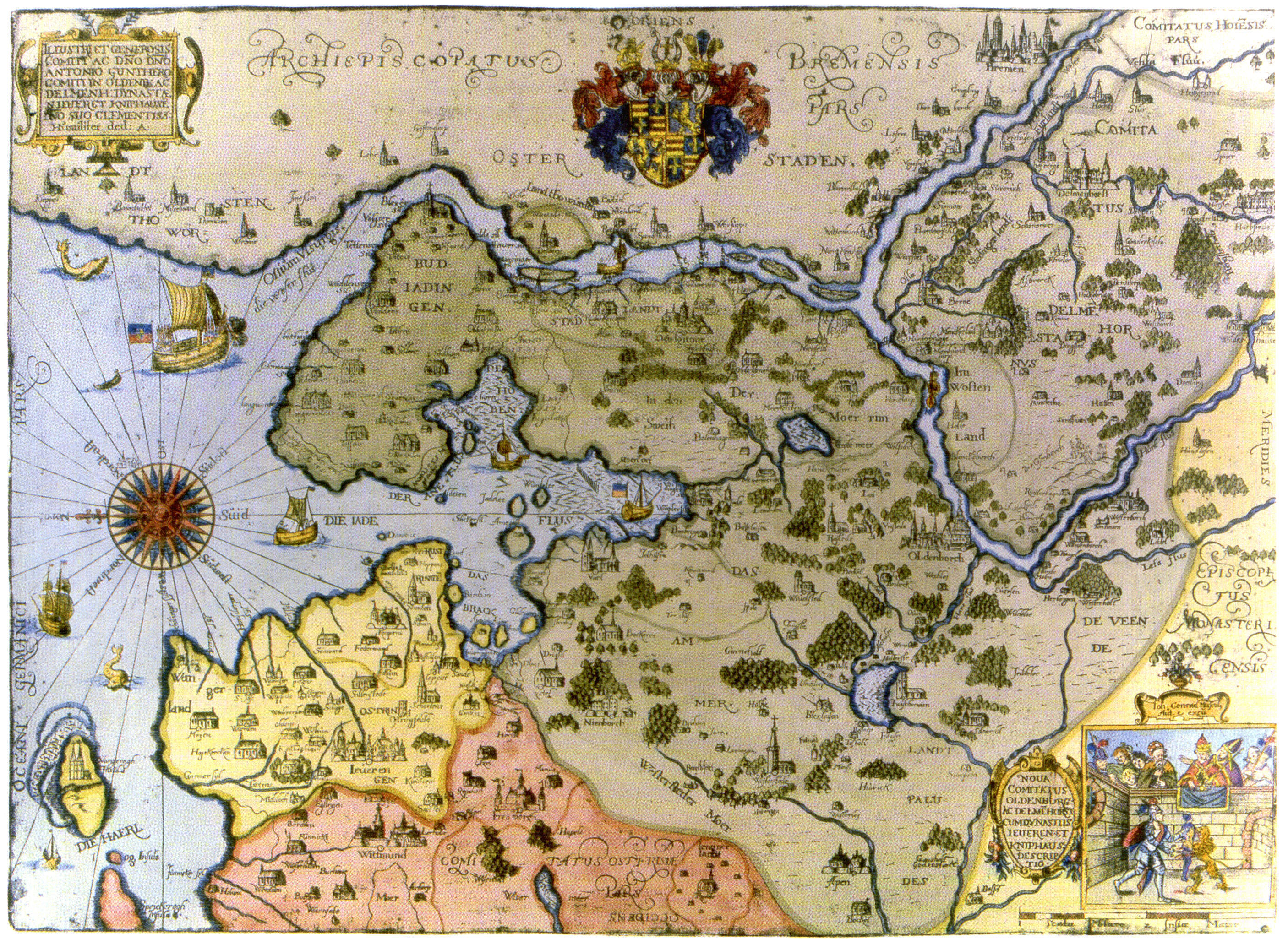
- Johann Conrad Musculus: Noua Comitatus Oldenburg … (1621/1650) Von dieser Karte wurden mehrere Inseln übernommen und der Landgewinn 1555 zwischen Eiswürden und Eckwarden. Die laut Oskar Tenge (s.u.) unter Berufung auf Ludwig Kohli (1828) 1555/1556 erfolgte Neueindeichung zwischen Eckwarder Hörne und Stollhamm ist nicht als Landgewinn dargestellt..
- Gerhart Muntinck: Accurata Descriptio Comitatus Oldenburgici & Delmenhorstanai (um 1648)
- Johann Wilhelm Anton Hunrichs: Herzogtum Oldenburg (1763)
- Delineation der Jade und der Made mit ihren Deichen und Vorlanden, Oldenburgische Karte von 1599 für das Reichskammergericht in Speyer zum Prozess um den Ellenser Damm, Landesachiv Oldenburg Best. 298 F A Nr. 118, auch bei Behre (s.o.) als Abb. 126, S. 131, sowie abgezeichnet mit teilweise abweichender Beschriftung („Ahmer Kirchhof“ statt „Seedieker K.“) als Fig. 1 in der Tenge-Zusammenstellung 1599–1625 (s.u.)
- Johann Conrad Musculus (?): Weser von incl. Bremen bis zur Mündung, 2. Viertel des 17. Jahrhunderts (Original im Stadtarchiv Lüneburg)
- Johann Conrad Musculus: Deichatlas 1625 archive copy at the Wayback Machine
- Johann Conrad Musculus: Abriss der Oberahneschen Felder (1645), Landesachiv Oldenburg Best. 298 Z Nr. 652, drei Versionen mit unterschiedlichen Details:
- a) mit mehreren Deichscharts aber ohne „Neue (Ahne-) Ahnesiel" oder „Ahnezuschlag“ im alten Hobendeich, auch in der Tenge-Zusamenstellung zum Butjadinger Deichband (s.u.) als Tafel 11 links
- b) mit „Neue Ahnesiel“ im alten Hobendeich
- c) mit „Ahnezuschlag“, auch im erklärenden Nachspann des Nachdrucks des Deichatlas abgebildet
- Anonyme Karte der oldenburgischen Deiche um 1650 (Landesarchiv Oldenburg Best. 298 Z Nr. 272)
- Oldenburgische Vogteikarten 1790 (leider nicht als Faksimile, sondern in moderner Aufarbeitung, daher mit heutigem Blattschnitt und heutigen Nummern):
- 2516 Nordenham (Atens) / 2517 Loxstedt (Dedesdorf) (Landesachiv Oldenburg, Best. 298 Nr. 26-2)
- 2616 Brake (Ovelgönne) (Oldenburgisches Landesarchiv, Best. 298 Nr. 28-1)
- 2715 Rastede
- 2716 Elsfleth (Oldenburgisches Landesarchiv, Best. 298 Nr. 32-1)
- Hannoversche Landesaufnahme 1764–1786
- Karl Ludwig von Le Coq: Topographische Karte in XXII Blaettern den grösten Theil von Westphalen enthaltend, so wie auch das Herzogthum Westphalen und einen Theil der Hannövrischen, Braunschweigischen und Hessischen Länder. Nach astronomischen und trignometrischen Orts-bestimmungen auf Befehl Seiner Majestät Friedrich Wilhelms III., Königs von Preussen, herausgegeben vom General Major von Le Coq im Jahr 1805 (tatsächlich 1805 – 1814)
- Kartenarchiv der Universität Greifswald archive copy at the Wayback Machine: Messtischblätter:
- 2315 Langwarden (1891)[dead link]
- 2316 Schmarren (1891) archive copy at the Wayback Machine mit Schmarren (Wursten) und Fedderwarder Wurth (Butjadingen)
- 2413 Jever (1906) archive copy at the Wayback Machine
- 2414 Wilhelmshaven (1891) archive copy at the Wayback Machine
- 2415 Eckwarden (1891)[dead link]
- 2416 Stollhamm (1911)[dead link]
- 2417 Bremerhaven (1905) archive copy at the Wayback Machine
- 2513 Neustadt-Gödens (1906) archive copy at the Wayback Machine
- 2514 Steinhausen (1906) archive copy at the Wayback Machine
- 2515 Jadebusen (1898) archive copy at the Wayback Machine
- 2515 Jadebusen (1940) archive copy at the Wayback Machine
- 2516 Nordenham (1908) archive copy at the Wayback Machine
- 2517 Loxstedt (1898)[dead link]
- 2615 Jaderberg (1898) archive copy at the Wayback Machine
- 2616 Brake (1905) archive copy at the Wayback Machine
- 2617 Hagen im Bremischen (1898) archive copy at the Wayback Machine
- 2715 Rastede (1906) archive copy at the Wayback Machine
- 2716 Elsfleth (1898) archive copy at the Wayback Machine
- 2717 Schwanewede 1898 archive copy at the Wayback Machine
- Karte von Bremerhaven 1848
- Ludwig Kohli, Handbuch einer historisch-statistisch-geographischen Beschreibung des Herzogthums Oldenburg (1828), 2. Abschnitt: Topographie des Herzogthums Oldenburg (Google-Digitalisat)
- Oskar Tenge: Der Jeversche Deichband (1898, Nachdruck 1999) ISBN 3-9806956-0-3 (Wangerland bis Ellenserdammer Tief)
- Oskar Tenge Tenge: 18 Karten zum Jeverschen Deichband
- Copien alter Karte der Jade und Theilen derselben 1599–1625 (1884)
- Bedeichungen im Raum Sande-Cäciliengroden (1898 auf Kartengrundlage vor 1888), auch bei Behre (s.o.) Abb.124, S. 127
- Oskar Tenge: Der Butjadinger Deichband (1912) (von einschl. Dangast bis zur Huntemündung), u. a. im Fundus (Vorbestellung) des Staatsarchivs Bremen
- Oskar Tenge: 25 Karten zum Butjadinger Deichband, 1912 archive copy at the Wayback Machine (PDF)
- G. Sello: Der Jadebusen, Varel, 1903
- H. Goens u. B. Ramsauer: Stedingen beiderseits der Hunte …, in Oldenburger Jahrbuch des Vereins für Altertumskunde Bd. 28 (1924), § 11. Der Linebrok(PDF)
- H. Goens: Die Bauernhöfe der Vormarsch und des Wüstenlandes, in Oldenburger Jahrbuch des Vereins für Altertumskunde Bd. 33 (1929)(PDF)
- Arbeitsgemeinschaft Archäologische Denkmalpflege Oldenburg: Archäologie von Großenmeer archive copy at the Wayback Machine
Licensing
I, the copyright holder of this work, hereby publish it under the following license:
This file is licensed under the Creative Commons Attribution-Share Alike 3.0 Unported license.
- You are free:
- to share – to copy, distribute and transmit the work
- to remix – to adapt the work
- Under the following conditions:
- attribution – You must give appropriate credit, provide a link to the license, and indicate if changes were made. You may do so in any reasonable manner, but not in any way that suggests the licensor endorses you or your use.
- share alike – If you remix, transform, or build upon the material, you must distribute your contributions under the same or compatible license as the original.
File history
Click on a date/time to view the file as it appeared at that time.
| Date/Time | Thumbnail | Dimensions | User | Comment | |
|---|---|---|---|---|---|
| current | 16:23, 1 October 2018 | | 3,365 × 3,231 (655 KB) | Ulamm | + brackets |
| 16:17, 1 October 2018 |  | 3,365 × 3,231 (655 KB) | Ulamm | Das Hohe Moor | |
| 15:14, 20 October 2014 |  | 3,365 × 3,231 (585 KB) | Kopiersperre | optipng | |
| 16:08, 18 October 2014 |  | 3,365 × 3,231 (653 KB) | Ulamm | + Jaderaußendeich | |
| 19:04, 18 April 2014 |  | 3,365 × 3,231 (652 KB) | Ulamm | Pleistocene under ancient Oldenbrügge above sea level | |
| 16:39, 23 March 2014 |  | 3,365 × 3,231 (651 KB) | Ulamm | three more dates of dikes | |
| 02:07, 23 March 2014 |  | 3,365 × 3,231 (651 KB) | Ulamm | dikes near Lockfleth and near the Weser obtained from Le Coq | |
| 20:27, 22 March 2014 |  | 3,365 × 3,231 (650 KB) | Ulamm | possible extension of Würdeleh | |
| 19:17, 22 March 2014 |  | 3,365 × 3,231 (649 KB) | Ulamm | some more names | |
| 00:21, 20 March 2014 |  | 3,365 × 3,231 (640 KB) | Ulamm | position of "Eckwarden" adjusted; (questioned) date of Hayenschloot cutting dike according to Tenge/Kohli |
File usage
The following pages on the English Wikipedia use this file (pages on other projects are not listed):
Global file usage
The following other wikis use this file:
- Usage on da.wikipedia.org
- Usage on de.wikipedia.org
- Usage on et.wikipedia.org
- Usage on frr.wikipedia.org
- Usage on fr.wikipedia.org
- Usage on nl.wikipedia.org
- Usage on ru.wikipedia.org
- Usage on sv.wikipedia.org