
File:Isaanmountains.svg

Size of this PNG preview of this SVG file: 667 × 600 pixels. Other resolutions: 267 × 240 pixels | 534 × 480 pixels | 855 × 768 pixels | 1,139 × 1,024 pixels | 2,279 × 2,048 pixels | 672 × 604 pixels.
Original file (SVG file, nominally 672 × 604 pixels, file size: 1.23 MB)
| This is a file from the Wikimedia Commons. Information from its description page there is shown below. Commons is a freely licensed media file repository. You can help. |
| Description |
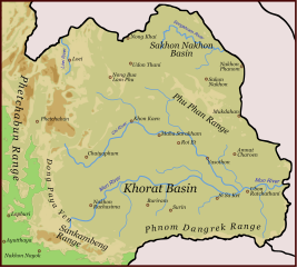
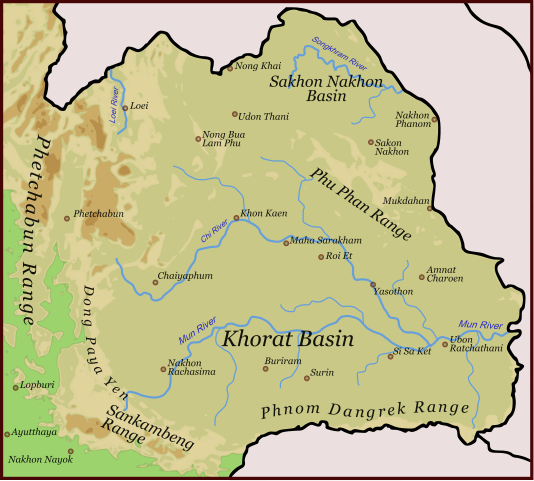
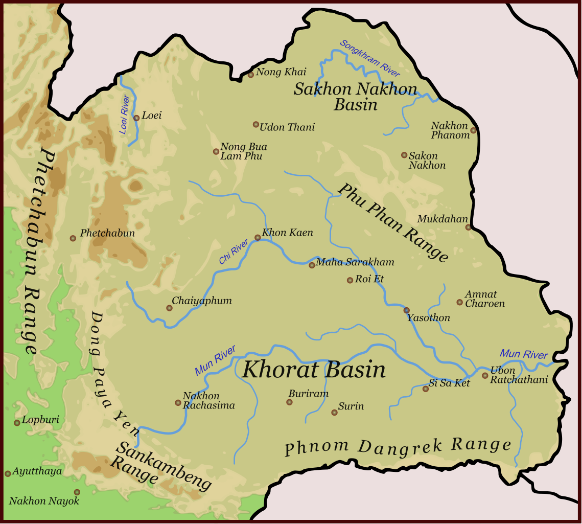
English: Physical orientation map of North-East-Thailand |
||
| Date | |||
| Source | Own work | ||
| Author | Hdamm | ||
| Permission (Reusing this file) |
I, the copyright holder of this work, hereby publish it under the following licenses:
This file is licensed under the Creative Commons Attribution-Share Alike 4.0 International, 3.0 Unported, 2.5 Generic, 2.0 Generic and 1.0 Generic license.
You may select the license of your choice. |
||
| Other versions | Isaanmountains.png |

This W3C-unspecified vector image was created with Inkscape .
File history
Click on a date/time to view the file as it appeared at that time.
| Date/Time | Thumbnail | Dimensions | User | Comment | |
|---|---|---|---|---|---|
| current | 12:07, 6 January 2017 | | 672 × 604 (1.23 MB) | Paul 012 | Shrink Dong Phaya Yen label, since it encroached into the Eastern Petchabun Range area |
| 13:28, 17 September 2008 |  | 672 × 604 (1.28 MB) | Hdamm | {{Information |Description= |Source= |Date= |Author= |Permission= |other_versions= }} | |
| 15:05, 22 August 2008 |  | 1,052 × 744 (1.28 MB) | Hdamm | {{Information |Description= |Source= |Date= |Author= |Permission= |other_versions= }} | |
| 08:53, 13 June 2008 |  | 672 × 604 (1.22 MB) | Hdamm | {{Information |Description= |Source= |Date= |Author= |Permission= |other_versions= }} | |
| 16:11, 31 May 2008 |  | 672 × 604 (1.17 MB) | Hdamm | {{Information |Description= |Source= |Date= |Author= |Permission= |other_versions= }} | |
| 13:40, 31 May 2008 |  | 672 × 604 (769 KB) | Hdamm | {{Information |Description= |Source= |Date= |Author= |Permission= |other_versions= }} | |
| 13:38, 31 May 2008 |  | 1,052 × 744 (768 KB) | Hdamm | {{Information |Description={{en|1=Physical orientation map of North-East-Thailand }} |Source=Own work by uploader |Author=Hdamm |Date=31.05.2008 |Permission={{self|GFDL|cc-by-sa-all}} |other_versions= }} {{ImageUpload|full}} [[Category:[[C |
File usage
The following pages on the English Wikipedia use this file (pages on other projects are not listed):
Global file usage
The following other wikis use this file:
- Usage on ar.wikipedia.org
- Usage on be.wikipedia.org
- Usage on bg.wikipedia.org
- Usage on ca.wikipedia.org
- Usage on de.wikipedia.org
- Usage on es.wikipedia.org
- Usage on et.wikipedia.org
- Usage on eu.wikipedia.org
- Usage on hi.wikipedia.org
- Usage on it.wikipedia.org
- Usage on ja.wikipedia.org
- Usage on km.wikipedia.org
- Usage on ko.wikipedia.org
- Usage on lt.wikipedia.org
- Usage on ml.wikipedia.org
- Usage on nl.wikipedia.org
- Usage on no.wikipedia.org
- Usage on pt.wikipedia.org
- Usage on ru.wikipedia.org
- Usage on sh.wikipedia.org
- Usage on th.wikipedia.org
- Usage on vi.wikipedia.org
- Usage on www.wikidata.org
- Usage on zh.wikipedia.org