
File:Irrigation Project along the Orange River.jpg

Size of this preview: 526 × 599 pixels. Other resolutions: 211 × 240 pixels | 421 × 480 pixels | 674 × 768 pixels | 898 × 1,024 pixels | 1,797 × 2,048 pixels | 3,159 × 3,600 pixels.
Original file (3,159 × 3,600 pixels, file size: 2.84 MB, MIME type: image/jpeg)
| This is a file from the Wikimedia Commons. Information from its description page there is shown below. Commons is a freely licensed media file repository. You can help. |
Summary
| Description |
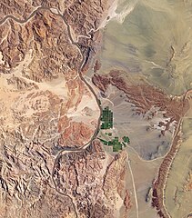
English: Along the banks of this river, roughly 100 kilometres inland from where the river empties into the Atlantic Ocean, irrigation projects take advantage of water from the river and soils from the floodplains to grow produce, turning parts of a normally earth-toned landscape emerald green. A network of bright rectangles of varying shades of green contrasts with surroundings of grey, beige, tan, and rust. Immediately south of a large collection of irrigated plots, faint beige circles reveal centre-pivot irrigation fields apparently allowed to go fallow. |
| Date | |
| Source | NASA Earth Observatory |
| Author | Jesse Allen |
Image captured by the Advanced Land Imager (ALI) on NASA’s Earth Observing-1 (EO-1) satellite.
Licensing
| This file is in the public domain in the United States because it was solely created by NASA. NASA copyright policy states that "NASA material is not protected by copyright unless noted". (See Template:PD-USGov, NASA copyright policy page or JPL Image Use Policy.) | ||
 |
Warnings:
|
File history
Click on a date/time to view the file as it appeared at that time.
| Date/Time | Thumbnail | Dimensions | User | Comment | |
|---|---|---|---|---|---|
| current | 13:24, 8 March 2010 | | 3,159 × 3,600 (2.84 MB) | Originalwana | {{Information |Description={{en|1=Along the banks of this river, roughly 100 kilometres inland from where the river empties into the Atlantic Ocean, irrigation projects take advantage of water from the river and soils from t |
File usage
The following pages on the English Wikipedia use this file (pages on other projects are not listed):
Global file usage
The following other wikis use this file:
- Usage on ca.wikipedia.org
- Usage on fi.wikipedia.org
- Usage on fr.wikipedia.org
- Usage on is.wikipedia.org
- Usage on sl.wikipedia.org