
File:Interior view of utilidor passageway link between building nos. 101 and 102 showing waveguides on left and cable tray system on right sides. Note fire suppression water supply piping HAER AK-30-A-102.tif

Size of this JPG preview of this TIF file: 733 × 600 pixels. Other resolutions: 293 × 240 pixels | 587 × 480 pixels | 939 × 768 pixels | 1,251 × 1,024 pixels | 2,503 × 2,048 pixels | 5,176 × 4,236 pixels.
Original file (5,176 × 4,236 pixels, file size: 20.91 MB, MIME type: image/tiff)
| This is a file from the Wikimedia Commons. Information from its description page there is shown below. Commons is a freely licensed media file repository. You can help. |
Summary
| Title |
Interior view of utilidor passageway link between building nos. 101 and 102 showing waveguides on left and cable tray system on right sides. Note fire suppression water supply piping (upper center). Small maintenance 3-wheel vehicle at center (Note- similar vehicles still in use in 2001.) Official photograph BMEWS Project by Hansen, Photographic Services, Riverton, NJ, BMEWS, clear as negative no. A-101123. - Clear Air Force Station, Ballistic Missile Early Warning System Site II, One mile west of mile marker 293.5 on Parks Highway, 5 miles southwest of Anderson, Anderson, Denali Borough, AK |
|||
| Depicted place | Alaska; Denali Borough; Anderson | |||
| Medium | 4 x 5 in. | |||
| Current location |
Library of Congress Prints and Photographs Division Washington, D.C. 20540 USA http://hdl.loc.gov/loc.pnp/pp.print |
|||
| Accession number |
HAER AK-30-A-102 |
|||
| Credit line |
|
|||
| Source | https://www.loc.gov/pictures/item/ak0486.photos.193587p | |||
| Permission (Reusing this file) |
|

| Camera location | | View this and other nearby images on: OpenStreetMap |
|---|
File history
Click on a date/time to view the file as it appeared at that time.
| Date/Time | Thumbnail | Dimensions | User | Comment | |
|---|---|---|---|---|---|
| current | 23:21, 26 June 2014 | 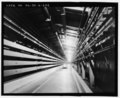 | 5,176 × 4,236 (20.91 MB) | Fæ | GWToolset: Creating mediafile for Fæ. HABS batch upload restart 26 June 2014 (p21:101)x |
File usage
The following pages on the English Wikipedia use this file (pages on other projects are not listed):
Global file usage
The following other wikis use this file:
- Usage on fa.wikipedia.org