
File:Indiana State Road 42 Bridge over Eel River, southern side and eastern portal.jpg

Size of this preview: 800 × 450 pixels. Other resolutions: 320 × 180 pixels | 640 × 360 pixels | 1,024 × 576 pixels | 1,280 × 720 pixels | 2,816 × 1,584 pixels.
Original file (2,816 × 1,584 pixels, file size: 2.62 MB, MIME type: image/jpeg)
| This is a file from the Wikimedia Commons. Information from its description page there is shown below. Commons is a freely licensed media file repository. You can help. |
|
This is an image of a place or building that is listed on the National Register of Historic Places in the United States of America. Its reference number is 210. |
| Camera location | | View this and other nearby images on: OpenStreetMap |
|---|
| Description |
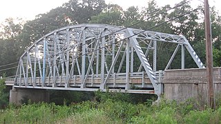
English: Southern (downstream) side and eastern portal of the Indiana State Highway Bridge 42-11-3101, which carries State Road 42 over the Eel River west of Poland in Cass Township, Clay County, Indiana, United States. Built in 1939, it is listed on the National Register of Historic Places. |
||
| Date | Taken on 4 July 2011 | ||
| Source | Own work | ||
| Author | Nyttend | ||
| Permission (Reusing this file) |
|
File history
Click on a date/time to view the file as it appeared at that time.
| Date/Time | Thumbnail | Dimensions | User | Comment | |
|---|---|---|---|---|---|
| current | 02:29, 7 July 2011 | | 2,816 × 1,584 (2.62 MB) | Nyttend | {{Location|39|26|40|N|86|59|37|W}} {{Information |Description={{en|Southern (downstream) side and eastern portal of the {{w|Indiana State Highway Bridge 42-11-3101}}, which carries {{w|Indiana State Road 42|State Road 42}} over the {{w|Eel River (White Ri |
File usage
The following pages on the English Wikipedia use this file (pages on other projects are not listed):
Global file usage
The following other wikis use this file:
- Usage on www.wikidata.org