
File:Imperial Japan map 1939.svg

Size of this PNG preview of this SVG file: 634 × 387 pixels. Other resolutions: 320 × 195 pixels | 640 × 391 pixels | 1,024 × 625 pixels | 1,280 × 781 pixels | 2,560 × 1,563 pixels.
Original file (SVG file, nominally 634 × 387 pixels, file size: 2.21 MB)
| This is a file from the Wikimedia Commons. Information from its description page there is shown below. Commons is a freely licensed media file repository. You can help. |
| Description |
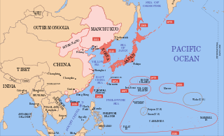
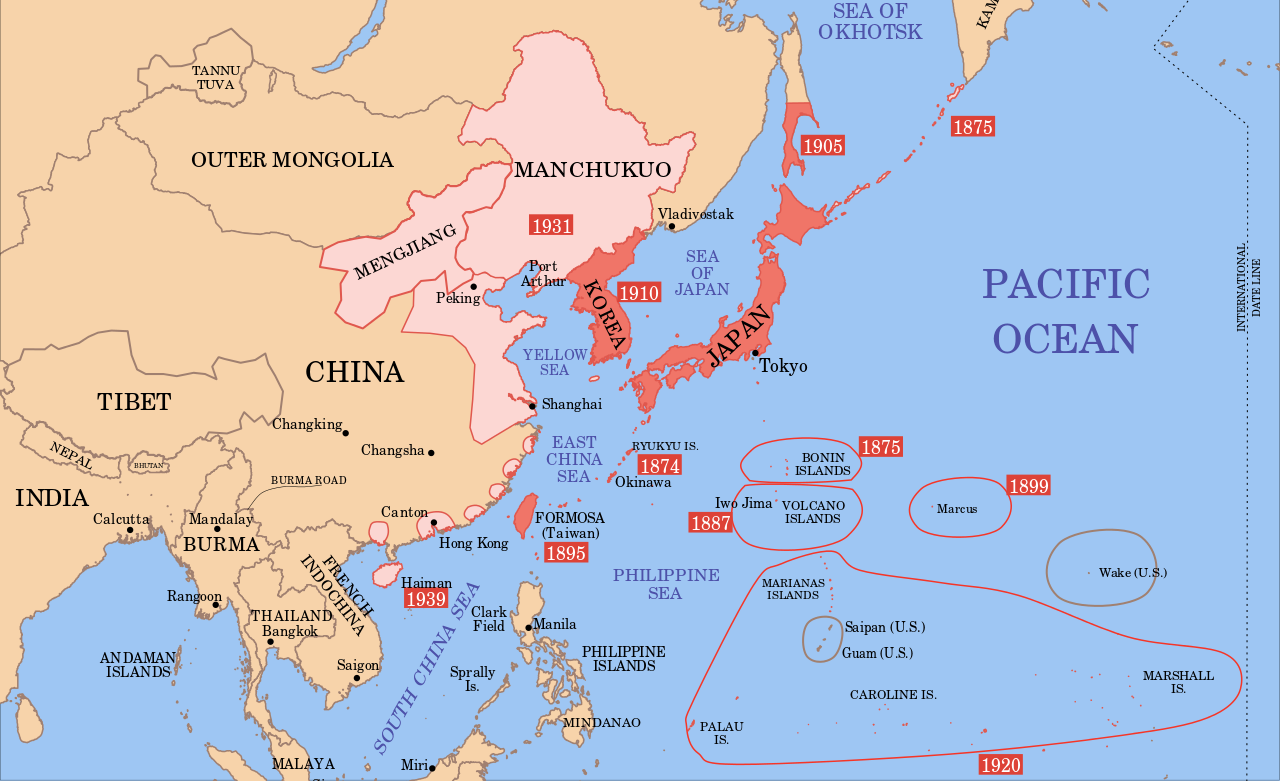
English: Imperial Japan 1939. |
| Date |
(UTC) 2008-08-01 |
| Source | |
| Author |
|

|
This SVG file contains embedded text that can be translated into your language, using any capable SVG editor, text editor or the SVG Translate tool. For more information see: About translating SVG files. |
| This is a retouched picture, which means that it has been digitally altered from its original version. Modifications: colour of countries. The original can be viewed here: Mengjiang map 1939.svg:
|
I, the copyright holder of this work, hereby publish it under the following license:
This file is licensed under the Creative Commons Attribution-Share Alike 3.0 Unported license.
- You are free:
- to share – to copy, distribute and transmit the work
- to remix – to adapt the work
- Under the following conditions:
- attribution – You must give appropriate credit, provide a link to the license, and indicate if changes were made. You may do so in any reasonable manner, but not in any way that suggests the licensor endorses you or your use.
- share alike – If you remix, transform, or build upon the material, you must distribute your contributions under the same or compatible license as the original.
Original upload log
This image is a derivative work of the following images:
- Image:Mengjiang_map_1939.svg licensed with Cc-by-sa-3.0, Cc-by-sa-3.0/en
- 2008-08-21T02:58:34Z Emok 634x387 (2316940 Bytes) {{Information |Description={{en|1=A map of Mengjiang, 1939-09-01. Dates shown indicate the approximate year that the various powers gain control of their possessions. Japanese control of territory in China was tenuous.}} |Sou
Uploaded with derivativeFX
File history
Click on a date/time to view the file as it appeared at that time.
| Date/Time | Thumbnail | Dimensions | User | Comment | |
|---|---|---|---|---|---|
| current | 03:45, 16 January 2012 | | 634 × 387 (2.21 MB) | Quigley | Xinjiang was not separate from China |
| 15:29, 16 December 2008 |  | 634 × 387 (2.21 MB) | Bamse | {{Information |Description={{en|1=Imperial Japan 1939.}} |Source=*Image:Mengjiang_map_1939.svg |Date=2008-12-16 15:25 (UTC) |Author=*derivative work: ~~~ *Image:Mengjiang_map_1939.svg: *derivative work: Emok ([[User talk:Emok|<sp |
File usage
The following pages on the English Wikipedia use this file (pages on other projects are not listed):
Global file usage
The following other wikis use this file:
- Usage on cs.wikipedia.org
- Usage on es.wikipedia.org
- Usage on fr.wikipedia.org
- Usage on sk.wikipedia.org