
File:Illogan Highway Methodist Church and Church Hall - geograph.org.uk - 1185643.jpg
Size of this preview: 509 × 600 pixels. Other resolutions: 204 × 240 pixels | 543 × 640 pixels.
Original file (543 × 640 pixels, file size: 78 KB, MIME type: image/jpeg)
| This is a file from the Wikimedia Commons. Information from its description page there is shown below. Commons is a freely licensed media file repository. You can help. |
Summary
| Description |
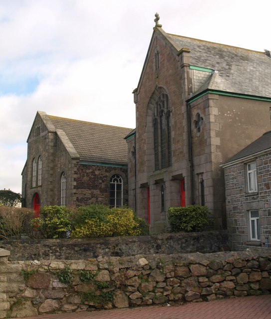
English: Illogan Highway Methodist Church and Church Hall These are the second and third Methodist chapels on this site; the first, dating from 1809, is a very modest single-storey building at the rear that is now the Sunday School. The further building dates from 1839 and is now a "meeting hall and Sunday School". See https://historicengland.org.uk/listing/the-list/list-entry/1328135 . The nearer building, of the early C20, has a "two-storey facade in free Gothic (or Arts and Crafts) style, in a form probably derived from that of its 1839 predecessor ..." https://historicengland.org.uk/listing/the-list/list-entry/1160343. Thomas Merritt, who composed several Christmas carols, including "Hark the Glad Sound! The Saviour Comes" and "Lo! He Comes, an Infant Stranger" was organist here from 1889 until his death in 1908.
All three buildings are built of killas, or metamorphic rock. |
| Date | |
| Source | From geograph.org.uk |
| Author | Derek Harper |
| Attribution (required by the license) | Derek Harper / Illogan Highway Methodist Church and Church Hall / |
| Camera location | | View this and other nearby images on: OpenStreetMap |
|---|
_heading:112.00&language=en)
| Object location | | View this and other nearby images on: OpenStreetMap |
|---|
_heading:112.00&language=en)
Licensing

|
This image was taken from the Geograph project collection. See this photograph's page on the Geograph website for the photographer's contact details. The copyright on this image is owned by Derek Harper and is licensed for reuse under the Creative Commons Attribution-ShareAlike 2.0 license.
|
This file is licensed under the Creative Commons Attribution-Share Alike 2.0 Generic license.
Attribution: Derek Harper
- You are free:
- to share – to copy, distribute and transmit the work
- to remix – to adapt the work
- Under the following conditions:
- attribution – You must give appropriate credit, provide a link to the license, and indicate if changes were made. You may do so in any reasonable manner, but not in any way that suggests the licensor endorses you or your use.
- share alike – If you remix, transform, or build upon the material, you must distribute your contributions under the same or compatible license as the original.
File history
Click on a date/time to view the file as it appeared at that time.
| Date/Time | Thumbnail | Dimensions | User | Comment | |
|---|---|---|---|---|---|
| current | 21:03, 25 February 2011 | | 543 × 640 (78 KB) | GeographBot | == {{int:filedesc}} == {{Information |description={{en|1=Illogan Highway Methodist Church and Church Hall These are the second and third Methodist chapels on this site; the first, dating from 1809, is a very modest single-storey building at the rear that |
File usage
The following pages on the English Wikipedia use this file (pages on other projects are not listed):
Global file usage
The following other wikis use this file:
- Usage on eu.wikipedia.org