
File:Iles Eparses-CIA WFB Map.png

Size of this preview: 468 × 600 pixels. Other resolutions: 187 × 240 pixels | 569 × 729 pixels.
Original file (569 × 729 pixels, file size: 27 KB, MIME type: image/png)
| This is a file from the Wikimedia Commons. Information from its description page there is shown below. Commons is a freely licensed media file repository. You can help. |
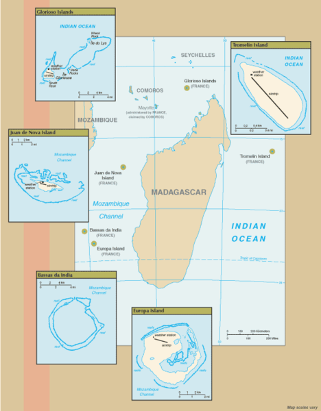
Summary
New map of Iles Eparses from 7 Sept 06 rev. of the World Factbook: https://www.cia.gov/cia/publications/factbook/geos/zz.html archive copy at the Wayback Machine
Licensing
This image is in the public domain because it contains materials that originally came from the United States Central Intelligence Agency's World Factbook.
|
 |
File history
Click on a date/time to view the file as it appeared at that time.
| Date/Time | Thumbnail | Dimensions | User | Comment | |
|---|---|---|---|---|---|
| current | 16:07, 8 September 2006 | | 569 × 729 (27 KB) | Hoshie | ==Summary== New map of Iles Eparses from 7 Sept 06 rev. of the World Factbook: [https://www.cia.gov/cia/publications/factbook/geos/zz.html https://www.cia.gov/cia/publications/factbook/geos/zz.html] ==Licensing== {{PD-USGov-CIA-WF}} |
File usage
The following pages on the English Wikipedia use this file (pages on other projects are not listed):
Global file usage
The following other wikis use this file:
- Usage on az.wikipedia.org
- Usage on es.wikipedia.org
- Usage on fa.wikipedia.org
- Usage on fr.wikipedia.org
- Usage on fr.wiktionary.org
- Usage on gcr.wikipedia.org
- Usage on hi.wikipedia.org
- Usage on id.wikipedia.org
- Usage on ka.wikipedia.org
- Usage on lv.wikipedia.org
- Usage on mg.wikipedia.org
- Usage on pnb.wikipedia.org
- Usage on simple.wikipedia.org
- Usage on sr.wikipedia.org
- Usage on sv.wikipedia.org
- Usage on uk.wikipedia.org
- Usage on ur.wikipedia.org
- Usage on zh.wikipedia.org