
File:Iberian Peninsula at Night - NASA Earth Observatory.jpg

Original file (1,440 × 960 pixels, file size: 588 KB, MIME type: image/jpeg)
| This is a file from the Wikimedia Commons. Information from its description page there is shown below. Commons is a freely licensed media file repository. You can help. |
Summary
| Description |
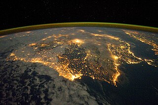
To download the full resolution and other files go to: earthobservatory.nasa.gov/IOTD/view.php?id=76777&src=... The city lights of Spain and Portugal define the Iberian Peninsula in this photograph from the International Space Station (ISS). Several large metropolitan areas are visible, marked by their relatively large and brightly lit areas, including the capital cities of Madrid, Spain—located near the center of the peninsula’s interior—and Lisbon, Portugal—located along the southwestern coastline. The ancient city of Seville, visible to the north of the Strait of Gibraltar, is one of the largest cities in Spain. The astronaut view is looking toward the east, and is part of a time-lapse series of images. The network of smaller cities and towns along the coastline and in the interior attest to the extent of the human presence on the Iberian landscape. The blurring of city lights is caused by thin cloud cover (image left and center), while cloud tops are dimly illuminated by moonlight. Though obscured, the lights of France are visible near the horizon line on the upper left, while the lights of northern Africa are more clearly discernable at right. The faint gold and green line of airglow—caused by ultraviolet radiation exciting the gas molecules in the upper atmosphere—parallels the horizon (or Earth limb). The Iberian Peninsula is the southwestern-most of the European peninsulas (together with the Italian and Balkan peninsulas), and includes the Principality of Andorra, as well as the Kingdom of Spain and the Portuguese Republic. The approximately 590,000 square kilometer landmass is bounded by the Atlantic Ocean to the northwest, west, and southwest and the Mediterranean Sea to the east. Its northeastern boundary is marked by the Pyrenees mountain range. Astronaut photograph ISS030-E-10008 was acquired on December 4, 2011, with a Nikon D3S digital camera using a 24 mm lens, and is provided by the ISS Crew Earth Observations experiment and Image Science & Analysis Laboratory, Johnson Space Center. The image was taken by the Expedition 30 crew. The image has been cropped and enhanced to improve contrast. Lens artifacts have been removed. The International Space Station Program supports the laboratory as part of the ISS National Lab to help astronauts take pictures of Earth that will be of the greatest value to scientists and the public, and to make those images freely available on the Internet. Additional images taken by astronauts and cosmonauts can be viewed at the NASA/JSC Gateway to Astronaut Photography of Earth. Caption by William L. Stefanov, Jacobs Technology/ESCG at NASA-JSC. The Earth Observatory's mission is to share with the public the images, stories, and discoveries about climate and the environment that emerge from NASA research, including its satellite missions, in-the-field research, and climate models. Like us on Facebook Follow us on Twitter Add us to your circles on Google+ |
| Date | |
| Source | Iberian Peninsula at Night |
| Author | NASA's Earth Observatory |
| Camera location | | View this and other nearby images on: OpenStreetMap |
|---|
Licensing
- You are free:
- to share – to copy, distribute and transmit the work
- to remix – to adapt the work
- Under the following conditions:
- attribution – You must give appropriate credit, provide a link to the license, and indicate if changes were made. You may do so in any reasonable manner, but not in any way that suggests the licensor endorses you or your use.
| This image was originally posted to Flickr by NASA Earth Observatory at https://www.flickr.com/photos/68824346@N02/6575192081. It was reviewed on 2 July 2012 by FlickreviewR and was confirmed to be licensed under the terms of the cc-by-2.0. |
File history
Click on a date/time to view the file as it appeared at that time.
| Date/Time | Thumbnail | Dimensions | User | Comment | |
|---|---|---|---|---|---|
| current | 13:36, 4 April 2018 | | 1,440 × 960 (588 KB) | Triplecaña | higher res taken from https://earthobservatory.nasa.gov/IOTD/view.php?id=76777&src=flickr |
| 17:16, 2 July 2012 |  | 720 × 480 (148 KB) | Dzlinker | == {{int:filedesc}} == {{Information |Description=To download the full resolution and other files go to: [http://earthobservatory.nasa.gov/IOTD/view.php?id=76777&src=flickr earthobservatory.nasa.gov/IOTD/view.php?id=76777&src=...] The city lights of S... |
File usage
Global file usage
The following other wikis use this file:
- Usage on ca.wikipedia.org
- Usage on es.wikipedia.org
- Usage on it.wikipedia.org
- Usage on sv.wikipedia.org
- Usage on tl.wikipedia.org