
File:ITC Guillaume 19 feb 2002 0620Z.jpg

Size of this preview: 600 × 600 pixels. Other resolutions: 240 × 240 pixels | 480 × 480 pixels | 768 × 768 pixels | 1,024 × 1,024 pixels | 2,048 × 2,048 pixels | 5,200 × 5,200 pixels.
Original file (5,200 × 5,200 pixels, file size: 4.16 MB, MIME type: image/jpeg)
| This is a file from the Wikimedia Commons. Information from its description page there is shown below. Commons is a freely licensed media file repository. You can help. |
Summary
| Description |
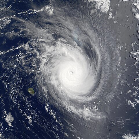
Projected to weaken over the coming day, Tropical Storm Guillaume was still going strong in the Indian Ocean in this Moderate Resolution Imaging Spectroradiometer (MODIS) image made from data acquired at 10:20 am local time on Tuesday, February 19, 2002. Shown here to the northeast of the French island of Réunion in the southwestern Indian Ocean off the coast of Madagascar, the outer bands of the storm clouds are obscuring the island of Mauritius, northeast of Réunion. The storm has been tracking slowly south-southeast, and should weaken as it moves farther south. As of Wednesday morning, February 20, maximum sustained winds were around 140 miles per hour (mph), with gusts of up to 167 mph. Waves were as high 24 ft. January and February are the peak cyclone months in the region, and Mauritius experiences on average about 10 each season. |
|||||
| Date | ||||||
| Source | http://visibleearth.nasa.gov/view_rec.php?id=2450 | |||||
| Author | Jacques Descloitres, MODIS Land Rapid Response Team, NASA/GSFC | |||||
| Permission (Reusing this file) |
|
|||||
| Other versions | Image:TC Guillaume 19 feb 2002 0620Z.jpg |

File history
Click on a date/time to view the file as it appeared at that time.
| Date/Time | Thumbnail | Dimensions | User | Comment | |
|---|---|---|---|---|---|
| current | 21:06, 10 October 2006 | | 5,200 × 5,200 (4.16 MB) | Good kitty | == Summary == {{Information |Description=Projected to weaken over the coming day, Tropical Storm Guillaume was still going strong in the Indian Ocean in this Moderate Resolution Imaging Spectroradiometer (MODIS) image made from data acquired at 10:20 am l |
File usage
The following pages on the English Wikipedia use this file (pages on other projects are not listed):
Global file usage
The following other wikis use this file:
- Usage on ca.wikipedia.org
- Usage on zh.wikipedia.org