
File:ISS021-E-15710 Pearl Harbor, Hawaii.jpg

Original file (4,288 × 2,848 pixels, file size: 11.07 MB, MIME type: image/jpeg)
| This is a file from the Wikimedia Commons. Information from its description page there is shown below. Commons is a freely licensed media file repository. You can help. |
Summary
| Description |
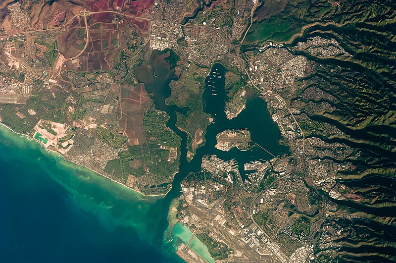
English: This detailed astronaut photograph illustrates the southern coastline of the Hawaiian island Oahu, including Pearl Harbor. On December 7, 1941—68 years ago—a surprise attack by the Japanese Navy on Pearl Harbor and other targets on the island of Oahu precipitated the entry of the United States into World War II. Today, Pearl Harbor is still in use as a major United States Navy installation, and along with Honolulu, it is one of the most heavily developed parts of the island.
A comparison between this image and a 2003 astronaut photograph of Pearl Harbor suggests that little observable land use or land cover change has occurred in the area over the past six years. The most significant difference is the presence of more naval vessels in the Reserve Fleet anchorage in Middle Loch (image center). The urban areas of Waipahu, Pearl City, and Aliamanu border the harbor to the northwest, north, and east. The built-up areas, recognizable by linear streets and white rooftops, contrast sharply with the reddish volcanic soils and green vegetation on the surrounding hills.
|
||||||||||||||||||||||||||||||||||||||||||||||||||
| Date | |||||||||||||||||||||||||||||||||||||||||||||||||||
| Source | http://eol.jsc.nasa.gov/scripts/sseop/photo.pl?mission=ISS021&roll=E&frame=15710 | ||||||||||||||||||||||||||||||||||||||||||||||||||
| Author |
|
||||||||||||||||||||||||||||||||||||||||||||||||||
| Other versions |
|
||||||||||||||||||||||||||||||||||||||||||||||||||

| Camera location | | View this and other nearby images on: OpenStreetMap |
|---|
| Object location | | View this and other nearby images on: OpenStreetMap |
|---|
This image or video was catalogued by Johnson Space Center of the United States National Aeronautics and Space Administration (NASA) under Photo ID: ISS021-E-15710. This tag does not indicate the copyright status of the attached work. A normal copyright tag is still required. See Commons:Licensing. Other languages:
|
Licensing
| This file is in the public domain in the United States because it was solely created by NASA. NASA copyright policy states that "NASA material is not protected by copyright unless noted". (See Template:PD-USGov, NASA copyright policy page or JPL Image Use Policy.) | ||
 |
Warnings:
|
| Annotations | This image is annotated: View the annotations at Commons |
File history
Click on a date/time to view the file as it appeared at that time.
| Date/Time | Thumbnail | Dimensions | User | Comment | |
|---|---|---|---|---|---|
| current | 17:34, 22 March 2013 | | 4,288 × 2,848 (11.07 MB) | Julian Herzog | User created page with UploadWizard |
File usage
Global file usage
The following other wikis use this file:
- Usage on bn.wikipedia.org
- Usage on ca.wikipedia.org
- Usage on de.wikipedia.org
- Usage on en.wikiversity.org
- Usage on es.wikipedia.org
- Usage on fr.wikipedia.org
- Usage on fy.wikipedia.org
- Usage on gn.wikipedia.org
- Usage on oc.wikipedia.org
- Usage on pt.wikipedia.org
- Usage on zh.wikipedia.org