
File:Hurricane Sally 2020 rainfall map.gif

Size of this preview: 658 × 600 pixels. Other resolutions: 263 × 240 pixels | 527 × 480 pixels | 855 × 779 pixels.
Original file (855 × 779 pixels, file size: 32 KB, MIME type: image/gif)
| This is a file from the Wikimedia Commons. Information from its description page there is shown below. Commons is a freely licensed media file repository. You can help. |
Summary
| Description |
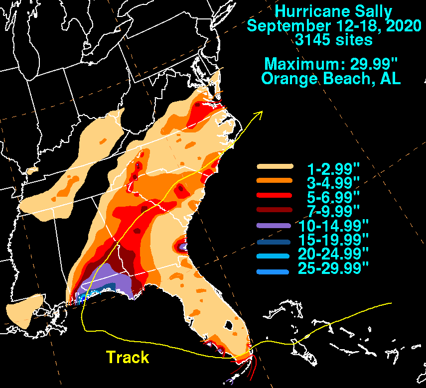
English: A map depicting total rainfall accumulations associated with Hurricane Sally in 2020 |
| Date | |
| Source | https://www.wpc.ncep.noaa.gov/tropical/rain/sally2020filledrainblk.gif |
| Author | Weather Prediction Center |
Licensing
This image is in the public domain because it contains materials that originally came from the U.S. National Oceanic and Atmospheric Administration, taken or made as part of an employee's official duties.
|
File history
Click on a date/time to view the file as it appeared at that time.
| Date/Time | Thumbnail | Dimensions | User | Comment | |
|---|---|---|---|---|---|
| current | 16:32, 9 September 2021 | | 855 × 779 (32 KB) | Cyclonebiskit | Uploaded a work by Weather Prediction Center from https://www.wpc.ncep.noaa.gov/tropical/rain/sally2020filledrainblk.gif with UploadWizard |
File usage
The following pages on the English Wikipedia use this file (pages on other projects are not listed):