
File:Ivan 2004-09-11 1610Z.jpg

Size of this preview: 461 × 599 pixels. Other resolutions: 184 × 240 pixels | 369 × 480 pixels | 591 × 768 pixels | 788 × 1,024 pixels | 1,575 × 2,048 pixels | 6,000 × 7,800 pixels.
Original file (6,000 × 7,800 pixels, file size: 6.58 MB, MIME type: image/jpeg)
| This is a file from the Wikimedia Commons. Information from its description page there is shown below. Commons is a freely licensed media file repository. You can help. |
Summary
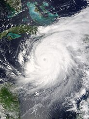
| Description |
The MODIS instrument aboard NASA's Terra satellite captured this true-color image of Hurricane Ivan on Septebmer 11, 2004 at 16:10 UTC (12:10 PM EDT). At the time this image was taken Ivan was located approximately 50 km (30 miles) southwest of the western tip of Jamaica and was moving towards the west-northwest at 13 km/hr (8 mph). Ivan had maximum sustained winds of 230 km/hr (145 mph) with higher gusts. The MODIS Rapid Response System provides this image at additional resolutions and formats. |
|||||
| Date | ||||||
| Source | http://earthobservatory.nasa.gov/NaturalHazards/natural_hazards_v2.php3?img_id=12428 | |||||
| Author | NASA image courtesy Jacques Descloitres, MODIS Land Rapid Response Team at NASA GSFC. | |||||
| Permission (Reusing this file) |
|

File history
Click on a date/time to view the file as it appeared at that time.
| Date/Time | Thumbnail | Dimensions | User | Comment | |
|---|---|---|---|---|---|
| current | 22:01, 8 November 2006 | | 6,000 × 7,800 (6.58 MB) | Good kitty | == Summary == {{Information |Description=The MODIS instrument aboard NASA's Terra satellite captured this true-color image of Hurricane Ivan on Septebmer 11, 2004 at 16:10 UTC (12:10 PM EDT). At the time this image was taken Ivan was located approximately |
File usage
The following pages on the English Wikipedia use this file (pages on other projects are not listed):
Global file usage
The following other wikis use this file:
- Usage on ca.wikipedia.org
- Usage on it.wikipedia.org
- Usage on jam.wikipedia.org
- Usage on pl.wikipedia.org
- Usage on ru.wikipedia.org
- Usage on th.wikipedia.org
- Usage on uk.wikipedia.org
- Usage on zh.wikipedia.org