
File:Huntington Solano-Reeve 1858 Rancho Los Alamitos survey map.jpg

Original file (7,291 × 4,183 pixels, file size: 5.24 MB, MIME type: image/jpeg)
| This is a file from the Wikimedia Commons. Information from its description page there is shown below. Commons is a freely licensed media file repository. You can help. |
Summary
| Description |
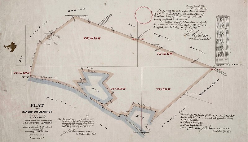
English: Huntington Solano-Reeve 1858 Rancho Los Alamitos survey map |
| Date | |
| Source |
Title Plat of the Rancho Los Alamitos finally confirmed to A. Stearns Creator Hancock, Henry, 1822-1883, surveyor. Date Searchable 1858-09 Date 1858 September Call Number SR_Map_0006 Physical Description 1 map ; 14 x 24 in., on sheet 17 3/4 x 29 3/4 in., ink on tracing cloth Scale 1 : 40 chains [1/2 mile] Location depicted Los Alamitos Los Alamitos, Rancho Description Bordered by Los Cerritos Rancho, Pacific Ocean, Rancho Bolsa Chica, Ranchos Los Bolsas, Rancho Los Coyotes. Surveyed under the Instructions from the U.S. Surveyor General. Approved 1860 & 1861 by J.W. Mandeville (?) and L. Upson, 1867, U.S. Surveyor Generals Cal.. Colored highlights around boundaries. Includes two bays and numerous sloughs. Boundary landmarks. T. IV S.R. XII W, T IV S.R. XI W., T V S.R. XIII W., T.V S.R. XI W., T V S.R. XII W.. Inset with table of boundary coordinates and distances Subjects California, Southern -- History -- 19th century. California, Southern -- History -- 20th century. Los Alamitos (Calif.) -- Maps. Los Angeles County (Calif.) -- Maps. Ranches -- California, Southern -- History. Real property -- California -- Los Alamitos. Los Alamitos (Calif.) -- Surveys. Surveying -- California, Southern -- History. Topographic maps. (aat) Topographic surveys. (aat) Historical maps. (aat) Contributor Stearns, Abel, 1798-1871. Physical Collection Solano-Reeve collection Rights For information on use of Digital Library materials, please see Library Rights and Permissions: https://www.huntington.org/library-rights-permissions Digital Collection Maps, Huntington Digital Library Digitization Specifications High Res Unique Digital Identifier 11795 IIIF Manifest https://hdl.huntington.org/iiif/info/p15150coll4/11301/manifest.json IIIF Image https://hdl.huntington.org/digital/iiif/p15150coll4/11301/full/full/0/default.jpg |
| Author | GLO/BLM |
Licensing
This work is in the public domain in the United States because it was published (or registered with the U.S. Copyright Office) before January 1, 1929.
Public domain works must be out of copyright in both the United States and in the source country of the work in order to be hosted on the Commons. If the work is not a U.S. work, the file must have an additional copyright tag indicating the copyright status in the source country.
Note: This tag should not be used for sound recordings. |
File history
Click on a date/time to view the file as it appeared at that time.
| Date/Time | Thumbnail | Dimensions | User | Comment | |
|---|---|---|---|---|---|
| current | 06:01, 31 March 2023 | | 7,291 × 4,183 (5.24 MB) | Jengod | Uploaded a work by GLO/BLM from Title Plat of the Rancho Los Alamitos finally confirmed to A. Stearns Creator Hancock, Henry, 1822-1883, surveyor. Date Searchable 1858-09 Date 1858 September Call Number SR_Map_0006 Physical Description 1 map ; 14 x 24 in., on sheet 17 3/4 x 29 3/4 in., ink on tracing cloth Scale 1 : 40 chains [1/2 mile] Location depicted Los Alamitos Los Alamitos, Rancho Description Bordered by Los Cerritos Rancho, Pacific Ocean, Rancho Bolsa Chica, Ranchos Los Bolsas, Ranch... |