
File:Huntington SR Box 20(01).04.jpg

Original file (3,623 × 5,665 pixels, file size: 2.65 MB, MIME type: image/jpeg)
| This is a file from the Wikimedia Commons. Information from its description page there is shown below. Commons is a freely licensed media file repository. You can help. |
.04.jpg)
Summary
| Description |
English: Huntington SR_Box_20(01).04 |
| Date | |
| Source |
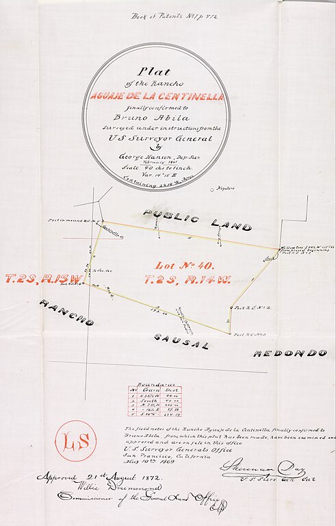
Title Plat of the Rancho Aguaje de la Centinela finally confirmed to Bruno Abila. Creator Hansen, George, 1824-1897, creator. Date Searchable 1868-02 Date 1868 February Call Number SR_Box_20(01).04 Physical Description 1 ms. map ; 6 x 8 in., on sheet 19 x 11 1/4 in., ink on tracing cloth Scale 1 : 40 chains Location depicted Inglewood Description Adjacent T. 2 S., R. 15 W., public land and Rancho Sausal Redondo. Color highlighted Lot No. 40 T. 2 S., R. 14 W., showing markers and coordinates; table of boundaries . Book of Patents No. 1 p. 572 Subjects California -- History -- 1850-1950. Hansen, George, 1824-1897. Historical maps. (aat) Inglewood (Calif.) Los Angeles County (Calif.) -- Maps. Ranches -- California, Southern -- Maps. Real property -- Maps. Surveying -- California, Southern -- History. Physical Collection Solano-Reeve collection Rights For information on use of Digital Library materials, please see Library Rights and Permissions: https://www.huntington.org/library-rights-permissions Digital Collection Maps, Huntington Digital Library Digitization Specifications High Res Unique Digital Identifier 313790 IIIF Manifest https://hdl.huntington.org/iiif/info/p15150coll4/12304/manifest.json IIIF Image https://hdl.huntington.org/digital/iiif/p15150coll4/12304/full/full/0/default.jpg |
| Author | U.S. Surveyor General |
Licensing
This work is in the public domain in the United States because it was published (or registered with the U.S. Copyright Office) before January 1, 1929.
Public domain works must be out of copyright in both the United States and in the source country of the work in order to be hosted on the Commons. If the work is not a U.S. work, the file must have an additional copyright tag indicating the copyright status in the source country.
Note: This tag should not be used for sound recordings. |
File history
Click on a date/time to view the file as it appeared at that time.
| Date/Time | Thumbnail | Dimensions | User | Comment | |
|---|---|---|---|---|---|
| current | 03:54, 22 November 2023 | | 3,623 × 5,665 (2.65 MB) | Jengod | Uploaded a work by U.S. Surveyor General from Title Plat of the Rancho Aguaje de la Centinela finally confirmed to Bruno Abila. Creator Hansen, George, 1824-1897, creator. Date Searchable 1868-02 Date 1868 February Call Number SR_Box_20(01).04 Physical Description 1 ms. map ; 6 x 8 in., on sheet 19 x 11 1/4 in., ink on tracing cloth Scale 1 : 40 chains Location depicted Inglewood Description Adjacent T. 2 S., R. 15 W., public land and Rancho Sausal Redondo. Color highlighted Lot No. 40 T. 2 S... |
.04.jpg)