
File:Hredle BE CZ 055.jpg

Size of this preview: 800 × 600 pixels. Other resolutions: 320 × 240 pixels | 640 × 480 pixels | 1,024 × 768 pixels | 1,280 × 960 pixels | 1,984 × 1,488 pixels.
Original file (1,984 × 1,488 pixels, file size: 1.8 MB, MIME type: image/jpeg)
| This is a file from the Wikimedia Commons. Information from its description page there is shown below. Commons is a freely licensed media file repository. You can help. |
Summary
| Description |
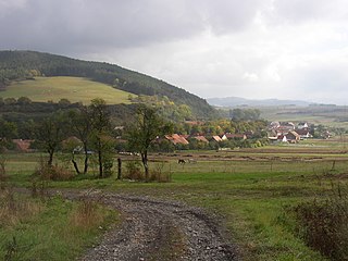
Čeština: Hředle, okres Beroun. Pohled od západu na dolejší, jihovýchodní část obce. V pozadí vlevo vrch Homole (426 m).
English: Hředle, Beroun District, Czech Republic. Lower (SE) part of the village as seen from the west. In the left background hill of Homole (426 m). |
| Date | |
| Source | Own work |
| Author | User:Miaow Miaow |
| Permission (Reusing this file) |
PD-self |
| Camera location | | View this and other nearby images on: OpenStreetMap |
|---|
Licensing
| I, the copyright holder of this work, release this work into the public domain. This applies worldwide. In some countries this may not be legally possible; if so: I grant anyone the right to use this work for any purpose, without any conditions, unless such conditions are required by law. |
File history
Click on a date/time to view the file as it appeared at that time.
| Date/Time | Thumbnail | Dimensions | User | Comment | |
|---|---|---|---|---|---|
| current | 18:15, 12 April 2008 | | 1,984 × 1,488 (1.8 MB) | Miaow Miaow | {{Information |Description= {{cs|'''Hředle''', okres Beroun. Pohled od západu na dolejší, jihovýchodní část obce. V pozadí vlevo vrch Homole (426 m).}} {{en|'''Hředle''', Beroun D |
File usage
The following pages on the English Wikipedia use this file (pages on other projects are not listed):
Global file usage
The following other wikis use this file:
- Usage on azb.wikipedia.org
- Usage on ceb.wikipedia.org
- Usage on ce.wikipedia.org
- Usage on cs.wikipedia.org
- Usage on eo.wikipedia.org
- Usage on es.wikipedia.org
- Usage on eu.wikipedia.org
- Usage on fa.wikipedia.org
- Usage on fr.wikipedia.org
- Usage on hu.wikipedia.org
- Usage on it.wikipedia.org
- Usage on lmo.wikipedia.org
- Usage on nl.wikipedia.org
- Usage on pl.wikipedia.org
- Usage on pt.wikipedia.org
- Usage on sk.wikipedia.org
- Usage on sr.wikipedia.org
- Usage on tt.wikipedia.org
- Usage on uz.wikipedia.org
- Usage on vi.wikipedia.org
- Usage on www.wikidata.org
- Usage on zh-min-nan.wikipedia.org