
File:Hot springs bathhouse row map.jpg

Size of this preview: 433 × 599 pixels. Other resolutions: 173 × 240 pixels | 574 × 794 pixels.
Original file (574 × 794 pixels, file size: 111 KB, MIME type: image/jpeg)
| This is a file from the Wikimedia Commons. Information from its description page there is shown below. Commons is a freely licensed media file repository. You can help. |
Summary
| Description |
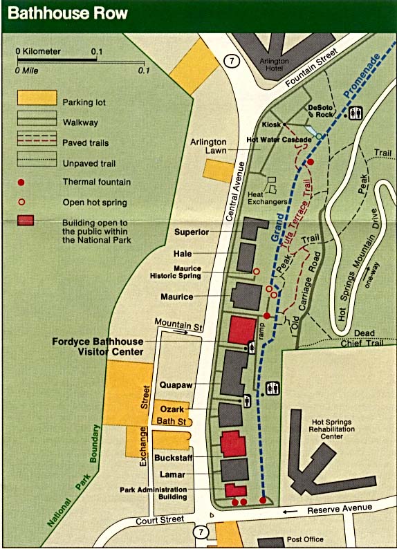
Map of Bathhouse Row, Hot Springs National Park — Arkansas.
|
| Date | |
| Source | http://www.lib.utexas.edu/maps/national_parks/hot_springs_bathhouse_row.jpg |
| Author |
Licensing
| This image or media file contains material based on a work of a National Park Service employee, created as part of that person's official duties. As a work of the U.S. federal government, such work is in the public domain in the United States. See the NPS website and NPS copyright policy for more information. |
File history
Click on a date/time to view the file as it appeared at that time.
| Date/Time | Thumbnail | Dimensions | User | Comment | |
|---|---|---|---|---|---|
| current | 21:08, 5 January 2008 | | 574 × 794 (111 KB) | SEWilco | {{Information |Description=Map of Bathhouse Row, Hot Springs National Park. Larger image of map on http://www.nps.gov/hosp/historyculture/bathhouse-row-today.htm. |Source=http://www.lib.utexas.edu/maps/national_parks/hot_springs_bathhouse_row.jpg |Date=2 |
File usage
The following pages on the English Wikipedia use this file (pages on other projects are not listed):