
File:Hopefield Railway.png

Size of this preview: 360 × 599 pixels. Other resolutions: 144 × 240 pixels | 288 × 480 pixels | 461 × 768 pixels | 615 × 1,024 pixels | 1,669 × 2,777 pixels.
Original file (1,669 × 2,777 pixels, file size: 690 KB, MIME type: image/png)
| This is a file from the Wikimedia Commons. Information from its description page there is shown below. Commons is a freely licensed media file repository. You can help. |
Summary
| Description |
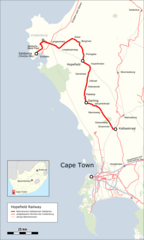
English: Map of Hopefield Railway |
| Date | |
| Source |
Map was created by using
|
| Author |
|
| Permission (Reusing this file) |
Map data (c) OpenStreetMap (and) contributors, CC-BY-SA |
Licensing
I, the copyright holder of this work, hereby publish it under the following license:
This file is licensed under the Creative Commons Attribution 3.0 Unported license.
- You are free:
- to share – to copy, distribute and transmit the work
- to remix – to adapt the work
- Under the following conditions:
- attribution – You must give appropriate credit, provide a link to the license, and indicate if changes were made. You may do so in any reasonable manner, but not in any way that suggests the licensor endorses you or your use.
| This work is licensed under the Open Database License (summary). |
File history
Click on a date/time to view the file as it appeared at that time.
| Date/Time | Thumbnail | Dimensions | User | Comment | |
|---|---|---|---|---|---|
| current | 09:11, 1 May 2017 | | 1,669 × 2,777 (690 KB) | Pechristener | Reverted to version as of 20:20, 5 March 2016 (UTC). Reason: article decided that Kalbaskraal is the desired wording |
| 05:37, 6 March 2016 |  | 1,669 × 2,777 (691 KB) | Pechristener | Kalbaskraal -> Kalabaskraal | |
| 20:20, 5 March 2016 |  | 1,669 × 2,777 (690 KB) | Pechristener | Saldanha Metal Plant added | |
| 19:55, 5 March 2016 |  | 1,669 × 2,777 (683 KB) | Pechristener | == {{int:filedesc}} == {{Information |Description ={{en|1=Map of Hopefield Railway}} |Source =Map was created by using * [http://www.openstreetmap.org/ Open Street Map] Data * [[:File:South_Africa_location_map.svg|... |
File usage
The following pages on the English Wikipedia use this file (pages on other projects are not listed):
Global file usage
The following other wikis use this file:
- Usage on de.wikipedia.org
- Usage on www.wikidata.org