
File:Holyoke Range map-en.svg

Size of this PNG preview of this SVG file: 800 × 219 pixels. Other resolutions: 320 × 88 pixels | 640 × 175 pixels | 1,024 × 280 pixels | 1,280 × 350 pixels | 2,560 × 700 pixels | 1,360 × 372 pixels.
Original file (SVG file, nominally 1,360 × 372 pixels, file size: 142 KB)
| This is a file from the Wikimedia Commons. Information from its description page there is shown below. Commons is a freely licensed media file repository. You can help. |
| Description |
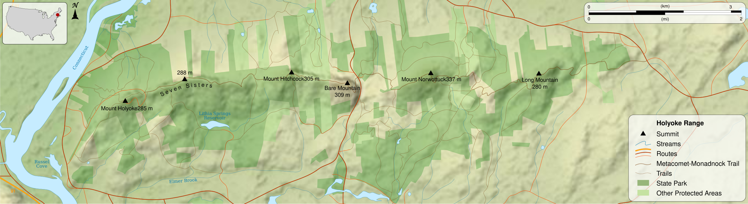
English: Map of Holyoke Range, a low fault-block mountain ridge, part of the Metacomet Ridge (itself part of the Appalachian Mountains), Massachusetts, United States of America. |
||
| Date | 2017-12-31; orig. 2010-10-15 17:30 (UTC) | ||
| Source |
French version; Source : * Topography : NASA Shuttle Radar Topography Mission (SRTM3 v.2) (public domain) ; * Rivers, towns, boundaries, roads and rails : NGDC World Data Bank II (public domain) and United States Geological Survey (public domain). * Location map : File:Blank US Map, Mainland with no States.svg by Lokal_Profil under licence CC-BY-SA 2.5 |
||
| Author | Sémhur (talk), translation by Simtropolitan | ||
| Permission (Reusing this file) |
This file is licensed under the Creative Commons Attribution-Share Alike 4.0 International, 3.0 Unported, 2.5 Generic, 2.0 Generic and 1.0 Generic license.
|
||
| Other versions | |||
| Attribution (required by the license) | © Sémhur / Wikimedia Commons / | ||
| SVG | W3C-validity not checked.
|
||
| Graphic Lab |

| Camera location | | View this and other nearby images on: OpenStreetMap |
|---|
}}
File history
Click on a date/time to view the file as it appeared at that time.
| Date/Time | Thumbnail | Dimensions | User | Comment | |
|---|---|---|---|---|---|
| current | 19:56, 9 November 2020 | 1,360 × 372 (142 KB) | Babbage | A few terms were not translated from the French original | |
| 00:03, 1 January 2018 | 1,360 × 372 (151 KB) | Simtropolitan | {{Information |Description ={{en|1=Map of Holyoke Range, a low fault-block mountain ridge, part of the Metacomet Ridge (itself part of the Appalachian Mountains), Massachusetts, United States of America.<br/>}} |Source... |
File usage
The following pages on the English Wikipedia use this file (pages on other projects are not listed):