
File:Holstein 1500.png
Holstein_1500.png (528 × 500 pixels, file size: 433 KB, MIME type: image/png)
| This is a file from the Wikimedia Commons. Information from its description page there is shown below. Commons is a freely licensed media file repository. You can help. |
Summary
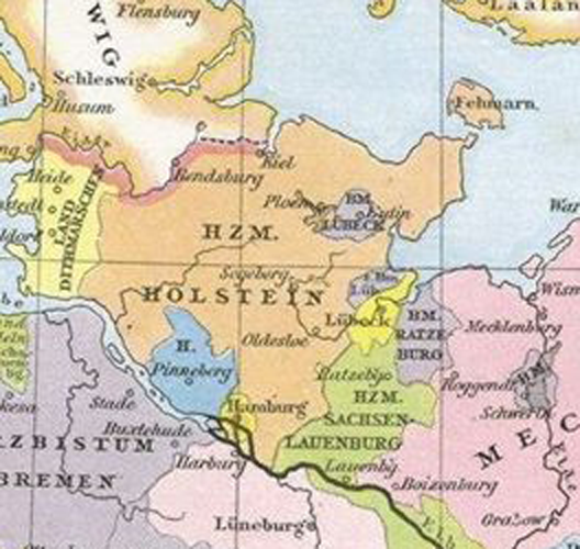
| Description |
English: This map comes from the map collection of Monumenta Germaniae Historica, specifically from: Germany in 15th century, from Allgemeiner historischer Handatlas (English: Historical Atlas) by Johann Gustav Droysen, 1886. It is in the public domain (http://141.84.81.24/cgi-bin/droysen.pl?karte=342).
Deutsch: Diese Karte stammt aus der Kartensammlung von Monumenta Germaniae Historica, speziell aus Deutschland im XV. Jahrhundert aus dem Allgemeinen historischen Handatlas von Johann Gustav Droysen, 1886. Es ist öffentlich freigegeben (http://141.84.81.24/cgi-bin/droysen.pl?karte=342). |
| Date | |
| Source | Johann Gustav Droysen, Allgemeiner historischer Handatlas in 96 Karten mit erläuterndem Text, Velhagen & Klasing 1886. Digitalized version: http://141.84.81.24/cgi-bin/droysen.pl?karte=342 |
| Author | Johann Gustav Droysen |
Licensing
|
This work is in the public domain in its country of origin and other countries and areas where the copyright term is the author's life plus 70 years or fewer.
| |
| This file has been identified as being free of known restrictions under copyright law, including all related and neighboring rights. | |
File history
Click on a date/time to view the file as it appeared at that time.
| Date/Time | Thumbnail | Dimensions | User | Comment | |
|---|---|---|---|---|---|
| current | 19:40, 9 February 2016 | | 528 × 500 (433 KB) | Heinrich.Airbus | Doppelte Bildgröße |
| 18:42, 9 February 2016 |  | 264 × 250 (138 KB) | Heinrich.Airbus | {{Information |Description ={{en|1=This map comes from the map collection of Monumenta Germaniae Historica, specifically from: Germany in 15th century, from Allgemeiner historischer Handatlas (English: Historical Atlas) by Johann Gustav Droysen, 188... |
File usage
Global file usage
The following other wikis use this file: