
File:Historical stylization — Slavic of the 12-13th centuries, Karoling Club Ruza.jpg

Size of this preview: 800 × 505 pixels. Other resolutions: 320 × 202 pixels | 640 × 404 pixels | 1,024 × 647 pixels | 1,280 × 808 pixels | 2,560 × 1,616 pixels | 5,333 × 3,367 pixels.
Original file (5,333 × 3,367 pixels, file size: 9.03 MB, MIME type: image/jpeg)
| This is a file from the Wikimedia Commons. Information from its description page there is shown below. Commons is a freely licensed media file repository. You can help. |
Summary
| Description |
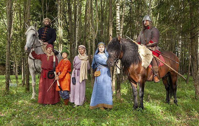
Русский: Занятие Клуба военно-исторической реконструкции Руси раннего средневековья «Каролинг» по подготовке к историческим фестивалям. Стилизованные образы русичей XII—XIII веков. Слева направо:
English: Training of the Club of military-historical reconstruction of Russia of the early Middle Ages "Caroling" in preparation for historical festivals. Stylized imagery of the Slavs of the 12th-13th centuries. From left to right:
Español: Practicando recreaciones históricas en preparación de las fiestas eslavas alta medievales (siglos XII y XIII) en el distrito urbano de Ruza, Óblast de Moscú, Rusia.
Polski: Członkowie rosyjskiego klubu rekonstrukcji historycznej „Karoling” z Ruzy w strojach wschodniosłowiańskich z XII–XIII wieku podczas przygotowań do festiwalu historycznego. |
||
| Date | |||
| Source | Karoling Ruza Historical Reconstruction Club / Клуб исторической реконструкции «Каролинг» г.Руза | ||
| Author | Dmitry Nikolaev / Дмитрий Николаев | ||
| Permission (Reusing this file) |
|||
| Note |
|
| Object location | | View this and other nearby images on: OpenStreetMap |
|---|
Assessment
|
This image was selected as picture of the day on Wikimedia Commons for 24 November 2021. It was captioned as follows: English: Training in preparation for Slavic festivals of the 12-13th centuries in the Ruza urban district of Moscow Oblast. Other languages:
Čeština: Příprava na historickou rekonstrukci slovanského svátku ze 12.-13. století v ruském městském okruhu v Moskevské oblasti. English: Training in preparation for Slavic festivals of the 12-13th centuries in the Ruza urban district of Moscow Oblast. Español: Practicando recreaciones históricas en preparación de las fiestas eslavas alta medievales (siglos XII y XIII) en el distrito urbano de Ruza, Óblast de Moscú, Rusia. Français : Les membres d'un club russe de reconstitution historique répètent en costume avant de participer à des festivals médiévaux. Sur cette photo, ils portent des vêtements slaves inspirés des XIIe et XIIIe siècles. Italiano: Addestramenti durante la preparazione dei festival slavi dei secoli XII–XIII nel distretto Ruzskij rajon di Oblast' di Mosca. Magyar: Középkori (12. és 13. századi) hu:történelmi életkép szláv fesztiválokra való felkészüléskor a Moszkvai terület Ruzai járásában (Oroszország) Nederlands: Deelnemers aan een historisch festival in het rajon Roezski in de Russische oblast Moskou Polski: Członkowie rosyjskiego klubu rekonstrukcji historycznej „Karoling” z Ruzy w strojach wschodniosłowiańskich z XII–XIII wieku podczas przygotowań do festiwalu historycznego. Português: Preparativos para as recriações históricas das festas eslavas medievais (séculos XII e XIII) no distrito de Ruzsky, região de Moscou, Rússia. Македонски: Подготовки за историскиот фестивал на XII и XIII век околу градот Руза, Московска област. Русский: Занятие по подготовке к историческим фестивалям XII-XIII веков в Рузском городском округе Московской области. Українська: Заняття Клубу реконструкції «Каролінги» раннього середньовіччя (XII-XIII століть) з підготовки до історичних фестивалів. Село Копцево, Росія. |
Licensing
This file is licensed under the Creative Commons Attribution-Share Alike 4.0 International license.
- You are free:
- to share – to copy, distribute and transmit the work
- to remix – to adapt the work
- Under the following conditions:
- attribution – You must give appropriate credit, provide a link to the license, and indicate if changes were made. You may do so in any reasonable manner, but not in any way that suggests the licensor endorses you or your use.
- share alike – If you remix, transform, or build upon the material, you must distribute your contributions under the same or compatible license as the original.
File history
Click on a date/time to view the file as it appeared at that time.
| Date/Time | Thumbnail | Dimensions | User | Comment | |
|---|---|---|---|---|---|
| current | 18:00, 3 September 2021 | | 5,333 × 3,367 (9.03 MB) | Niklitov | Cropped < 1 % horizontally, 5 % vertically using CropTool with precise mode. |
| 19:01, 27 August 2021 |  | 5,335 × 3,557 (7.73 MB) | Niklitov | Uploaded a work by [https://vk.com/nikolaev_foto Dmitry Nikolaev] / Дмитрий Николаев from Karoling Ruza Historical Reconstruction Club / [https://vk.com/karoling_ruza Клуб исторической реконструкции «Каролинг» г.Руза] with UploadWizard |
File usage
The following pages on the English Wikipedia use this file (pages on other projects are not listed):
Global file usage
The following other wikis use this file:
- Usage on alt.wikipedia.org
- Usage on av.wikipedia.org
- Usage on crh.wikipedia.org
- Usage on cv.wikipedia.org
- Usage on es.wikipedia.org
- Usage on fr.wikipedia.org
- Usage on hu.wikipedia.org
- Usage on hy.wikipedia.org
- Usage on it.wiktionary.org
- Usage on ka.wikipedia.org
- Usage on ko.wikipedia.org
- Usage on lbe.wikipedia.org
- Usage on lez.wikipedia.org
- Usage on mk.wikipedia.org
- Usage on os.wikipedia.org
- Usage on pt.wikipedia.org
- Usage on ru.wikipedia.org
- Usage on ru.wikimedia.org
- Usage on sah.wikipedia.org
- Usage on sk.wikipedia.org
- Usage on uk.wikipedia.org
- Usage on ur.wikipedia.org
- Usage on vep.wikipedia.org
- Usage on zh.wikipedia.org