
File:Historic Mokus of Maui Map.svg

Size of this PNG preview of this SVG file: 512 × 343 pixels. Other resolutions: 320 × 214 pixels | 640 × 429 pixels | 1,024 × 686 pixels | 1,280 × 858 pixels | 2,560 × 1,715 pixels.
Original file (SVG file, nominally 512 × 343 pixels, file size: 59 KB)
| This is a file from the Wikimedia Commons. Information from its description page there is shown below. Commons is a freely licensed media file repository. You can help. |
| Description |
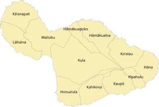
English: Map of the twelve historical mokus (districts) of Maui |
||
| Date | (UTC) | ||
| Source | Self, based on ahupuaʻa data by Hawaiian Gov't | ||
| Author | Sn1per (talk) | ||
| Permission (Reusing this file) |
|
||
| Other versions |
Deriatives:
Locator maps:
|

.svg)
.svg)
.svg)
.svg)
.svg)
.svg)
.svg)
.svg)
.svg)
.svg)
.svg)
.svg)
File history
Click on a date/time to view the file as it appeared at that time.
| Date/Time | Thumbnail | Dimensions | User | Comment | |
|---|---|---|---|---|---|
| current | 09:21, 12 April 2024 | | 512 × 343 (59 KB) | ערן | File uploaded using svgtranslate tool (https://svgtranslate.toolforge.org/). Added translation for he. |
| 03:28, 11 December 2011 |  | 512 × 343 (48 KB) | Sn1per | {{Information |Description ={{en|1=Map of the mokus of Maui}} |Source =Self, based on [http://hawaii.wr.usgs.gov/maui/data.html ahupuaʻa data by Hawaiian Gov't] |Author =~~~ |Date =~~~~~ |Permission ={{PD-self}} |other_ve |
File usage
The following pages on the English Wikipedia use this file (pages on other projects are not listed):
Global file usage
The following other wikis use this file:
- Usage on he.wikipedia.org