
File:Henry II Final Campaign.png
No higher resolution available.
Henry_II_Final_Campaign.png (365 × 315 pixels, file size: 159 KB, MIME type: image/png)
| This is a file from the Wikimedia Commons. Information from its description page there is shown below. Commons is a freely licensed media file repository. You can help. |
Summary
| Description |
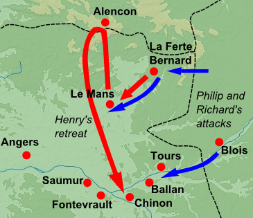
English: Blank topographic map of France in the official Lambert-93 projection. Note: The background map is a raster image embedded in the SVG file. Français : Carte topographique vierge de la France suivant la projection officielle Lambert-93. Note : Le fond de carte est une image bitmap embarquée dans le fichier SVG. Lambert-93 projection ; RGF-93 datum Scales: *Topography: 1:2,490,000 (precision 623 m) *Bathymetry: 1:7,640,000 (precision 1,910 m) |
| Date | (UTC) |
| Source |
France_map_Lambert-93_topographic-blank.svg; the information on the troop movements is from Warren's "Henry II", pp.624-625 Warren, W. L. (1973) Henry II, Berkeley and Los Angeles, CA: University of California Press, pp. 624−625 ISBN: 0-520-02282-3. |
| Author |
|
| This is a retouched picture, which means that it has been digitally altered from its original version. Modifications: Military data from 1189 added. The original can be viewed here: France map Lambert-93 topographic-blank.svg:
|
Licensing
I, the copyright holder of this work, hereby publish it under the following licenses:
This file is licensed under the Creative Commons Attribution-Share Alike 3.0 Unported, 2.5 Generic, 2.0 Generic and 1.0 Generic license.
- You are free:
- to share – to copy, distribute and transmit the work
- to remix – to adapt the work
- Under the following conditions:
- attribution – You must give appropriate credit, provide a link to the license, and indicate if changes were made. You may do so in any reasonable manner, but not in any way that suggests the licensor endorses you or your use.
- share alike – If you remix, transform, or build upon the material, you must distribute your contributions under the same or compatible license as the original.

|
Permission is granted to copy, distribute and/or modify this document under the terms of the GNU Free Documentation License, Version 1.2 or any later version published by the Free Software Foundation; with no Invariant Sections, no Front-Cover Texts, and no Back-Cover Texts. A copy of the license is included in the section entitled GNU Free Documentation License. |
You may select the license of your choice.
Original upload log
This image is a derivative work of the following images:
- File:France_map_Lambert-93_topographic-blank.svg licensed with Cc-by-sa-3.0,2.5,2.0,1.0, GFDL
- 2008-11-13T17:24:53Z Sting 2000x1898 (1639447 Bytes) + boundary for Channel Islands ; - canals
- 2008-10-01T04:59:44Z Sting 2000x1898 (1682809 Bytes) == Summary == {{Location|46|15|00|N|02|06|00|E|scale:10000000}} {{Information |Description={{en|Blank topographic map of [[:en:France|France]] in the official Lambert-93 projection.}} {{fr|Carte topographique vierge de la [[
Uploaded with derivativeFX
File history
Click on a date/time to view the file as it appeared at that time.
| Date/Time | Thumbnail | Dimensions | User | Comment | |
|---|---|---|---|---|---|
| current | 11:08, 31 December 2011 | | 365 × 315 (159 KB) | Hchc2009 | == {{int:filedesc}} == {{Information |Description={{en|Blank topographic map of France in the official Lambert-93 projection.<br/>''Note:'' The background map is a raster image embedded in the SVG file.}} {{fr|Carte topographique vierge de |
File usage
The following pages on the English Wikipedia use this file (pages on other projects are not listed):
Global file usage
The following other wikis use this file:
- Usage on da.wikipedia.org
- Usage on fr.wikipedia.org
- Usage on hu.wikipedia.org
- Usage on ko.wikipedia.org