
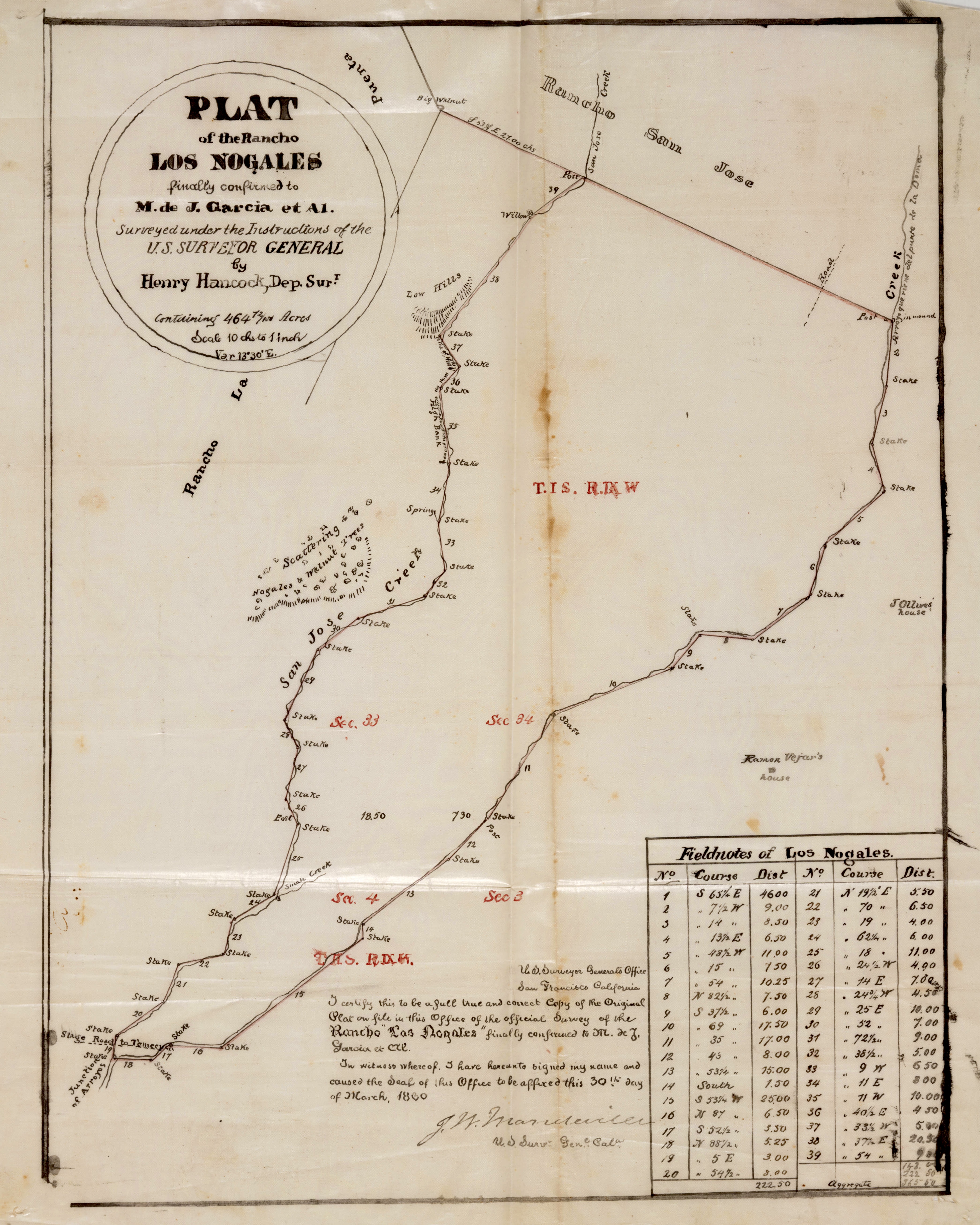
File:Henry Hancock 1860 U.S. Survey map of Rancho Los Nogales Walnut Los Angeles.jpg
Original file (4,183 × 5,229 pixels, file size: 5.05 MB, MIME type: image/jpeg)
| This is a file from the Wikimedia Commons. Information from its description page there is shown below. Commons is a freely licensed media file repository. You can help. |
Summary
| Description |
English: Henry Hancock 1860 U.S. Survey map of Rancho Los Nogales Walnut Los Angeles |
| Date | |
| Source |
Title Plat of the Rancho Los Nogales. Alt Title Rancho los Nogales : plat of the Rancho Los Nogales. Creator Hancock, Henry, 1822-1883, surveyor. Date Searchable 1860-03-30 Date 1860 March 30 Call Number SR_Box_22(03).03 Physical Description 1 ms. map ; 14 1/2 x 12 in., on sheet 18 x 14 3/4 in., ink on tracing cloth Scale 1 : 10 chains Location depicted Walnut Description Bordered by Ranchos San Jose, La Puente. Attached to certification sheet; showing section numbers, stations, stakes, surface details - hachures, walnut trees; San Jose Creek; table of courses, distances; certification declaration. Alt. title supplied by cataloger. Subjects California -- History -- 1850-1950. Historical maps. (aat) Maps Ranches -- California, Southern -- Maps. Real property -- Maps. Surveying -- California, Southern -- History. Walnut (Calif.) Physical Collection Solano-Reeve collection Rights For information on use of Digital Library materials, please see Library Rights and Permissions: https://www.huntington.org/library-rights-permissions Digital Collection Maps, Huntington Digital Library Digitization Specifications High Res Unique Digital Identifier 313863 IIIF Manifest https://hdl.huntington.org/iiif/info/p15150coll4/12378/manifest.json IIIF Image https://hdl.huntington.org/digital/iiif/p15150coll4/12378/full/full/0/default.jpg |
| Author | Henry Hancock |
Licensing
This work is in the public domain in the United States because it was published (or registered with the U.S. Copyright Office) before January 1, 1929.
Public domain works must be out of copyright in both the United States and in the source country of the work in order to be hosted on the Commons. If the work is not a U.S. work, the file must have an additional copyright tag indicating the copyright status in the source country.
Note: This tag should not be used for sound recordings. |
File history
Click on a date/time to view the file as it appeared at that time.
| Date/Time | Thumbnail | Dimensions | User | Comment | |
|---|---|---|---|---|---|
| current | 03:36, 1 April 2023 | | 4,183 × 5,229 (5.05 MB) | Jengod | Uploaded a work by Henry Hancock from Title Plat of the Rancho Los Nogales. Alt Title Rancho los Nogales : plat of the Rancho Los Nogales. Creator Hancock, Henry, 1822-1883, surveyor. Date Searchable 1860-03-30 Date 1860 March 30 Call Number SR_Box_22(03).03 Physical Description 1 ms. map ; 14 1/2 x 12 in., on sheet 18 x 14 3/4 in., ink on tracing cloth Scale 1 : 10 chains Location depicted Walnut Description Bordered by Ranchos San Jose, La Puente. Attached to certification sheet; showing se... |