
File:Henrietta Island, Russia.jpg

Size of this preview: 600 × 600 pixels. Other resolutions: 240 × 240 pixels | 480 × 480 pixels | 768 × 768 pixels | 1,024 × 1,024 pixels | 2,000 × 2,000 pixels.
Original file (2,000 × 2,000 pixels, file size: 2.22 MB, MIME type: image/jpeg)
| This is a file from the Wikimedia Commons. Information from its description page there is shown below. Commons is a freely licensed media file repository. You can help. |
Summary
| Description |
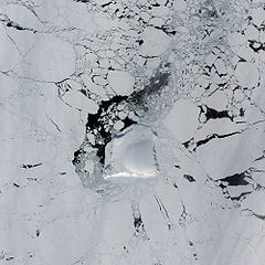
English: The Advanced Land Imager (ALI) on NASA’s Earth Observing-1 satellite captured this image of Henrietta Island. In this natural-color image, the island casts shadows to the north, thanks to the Sun’s low angle and the island’s own steep, rugged coastline. Inland, an icy dome covers most of the island, its southern surface slightly illuminated. |
| Date | |
| Source | NASA Earth Observatory |
| Author | Jesse Allen |
Instrument: EO-1 - ALI
Licensing
| This file is in the public domain in the United States because it was solely created by NASA. NASA copyright policy states that "NASA material is not protected by copyright unless noted". (See Template:PD-USGov, NASA copyright policy page or JPL Image Use Policy.) | ||
 |
Warnings:
|
| Annotations | This image is annotated: View the annotations at Commons |
File history
Click on a date/time to view the file as it appeared at that time.
| Date/Time | Thumbnail | Dimensions | User | Comment | |
|---|---|---|---|---|---|
| current | 11:23, 23 May 2009 | | 2,000 × 2,000 (2.22 MB) | Originalwana | {{Information |Description={{en|1=The Advanced Land Imager (ALI) on NASA’s Earth Observing-1 satellite captured this image of Henrietta Island. In this natural-color image, the island casts shadows to the north, thanks to the Sun’s low angle and the i |
File usage
The following pages on the English Wikipedia use this file (pages on other projects are not listed):
Global file usage
The following other wikis use this file:
- Usage on az.wikipedia.org
- Usage on be.wikipedia.org
- Usage on de.wikipedia.org
- Usage on he.wikipedia.org
- Usage on it.wikipedia.org
- Usage on ka.wikipedia.org
- Usage on lt.wikipedia.org
- Usage on mwl.wikipedia.org
- Usage on pl.wikipedia.org
- Usage on ru.wikipedia.org