
File:Helsinki map 1645.jpg
No higher resolution available.
Helsinki_map_1645.jpg (400 × 550 pixels, file size: 42 KB, MIME type: image/jpeg)
| This is a file from the Wikimedia Commons. Information from its description page there is shown below. Commons is a freely licensed media file repository. You can help. |
| Description |
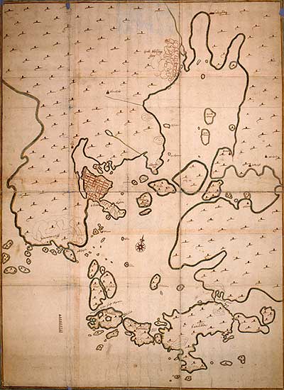
English: A map of Helsinki, Finland, 1645.
Suomi: Helsingin kartta vuodelta 1645. Karttaan on merkitty Vironniemi (nykyinen Helsingin keskusta) sekä Vantaanjoen suulla sijainnut Helsingin Vanhakaupunki. |
|||||||||
| Date | ||||||||||
| Source |
http://www.nba.fi/helsinginarkeologiaa/popup/1645.htm National Board of Antiquities, Helsinki Original map: Riksarkivet, Stockholm |
|||||||||
| Creator |
Hans Hansson |
|||||||||
| Geotemporal data | ||||||||||
| Bounding box |
|
|||||||||
| Georeferencing | ||||||||||
| Other versions |
 Crops: Image:Helsinki map 1645 Vanhakaupunki.jpg Image:Helsinki map 1645 Vironniemi.jpg |
|||||||||
|
This work is in the public domain in its country of origin and other countries and areas where the copyright term is the author's life plus 100 years or fewer. | |
| This file has been identified as being free of known restrictions under copyright law, including all related and neighboring rights. | |
File history
Click on a date/time to view the file as it appeared at that time.
| Date/Time | Thumbnail | Dimensions | User | Comment | |
|---|---|---|---|---|---|
| current | 22:41, 18 May 2008 | | 400 × 550 (42 KB) | Apalsola | {{Information |Description = {{en|A map of Helsinki, Finland, ca. 1645.}} {{fi|Helsingin kartta vuodelta 1645. Karttaan on merkitty Vironniemi (nykyinen Helsingin keskusta) sekä Vantaanjoen suulla sijainnut Helsingin Vanhakaupunki.}} |Source = http://ww |
File usage
No pages on the English Wikipedia use this file (pages on other projects are not listed).