
File:HegewaldColonyMap.png

Size of this preview: 800 × 470 pixels. Other resolutions: 320 × 188 pixels | 640 × 376 pixels | 1,024 × 602 pixels | 1,280 × 753 pixels | 1,803 × 1,060 pixels.
Original file (1,803 × 1,060 pixels, file size: 344 KB, MIME type: image/png)
| This is a file from the Wikimedia Commons. Information from its description page there is shown below. Commons is a freely licensed media file repository. You can help. |
| Description |
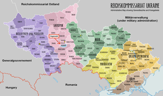
English: An administrative map of the Reichskommissariat Ukraine. Shows the boundaries of the Generalbezirke and Kreisgebiete as of September 1943. |
| Date | (UTC) |
| Source | |
| Author |
|
| This is a retouched picture, which means that it has been digitally altered from its original version. Modifications: Depicted the Hegewald colony. The original can be viewed here: ReichskommissariatUkraineMap.png:
|
I, the copyright holder of this work, hereby publish it under the following licenses:
| This file is licensed under the Creative Commons Attribution-Share Alike 3.0 Unported license. | ||
| ||
| This licensing tag was added to this file as part of the GFDL licensing update. |

|
Permission is granted to copy, distribute and/or modify this document under the terms of the GNU Free Documentation License, Version 1.2 or any later version published by the Free Software Foundation; with no Invariant Sections, no Front-Cover Texts, and no Back-Cover Texts. A copy of the license is included in the section entitled GNU Free Documentation License. |
You may select the license of your choice.
Original upload log
This image is a derivative work of the following images:
- File:ReichskommissariatUkraineMap.png licensed with Cc-by-sa-3.0-migrated, GFDL
- 2008-07-22T13:01:26Z XrysD 1803x1060 (209981 Bytes) {{Information |Description={{en|1=An administrative map of the Reichskommissariat Ukraine. Shows the boundaries of the Generalbezirke and Kreisgebiete as of September 1943.}} |Source=Own work by uploader |Author=[[User:XrysD|
Uploaded with derivativeFX
File history
Click on a date/time to view the file as it appeared at that time.
| Date/Time | Thumbnail | Dimensions | User | Comment | |
|---|---|---|---|---|---|
| current | 13:59, 25 April 2016 | | 1,803 × 1,060 (344 KB) | Poeticbent | factual error - "Generalgouvernement" - darkness |
| 09:32, 15 January 2011 |  | 1,803 × 1,060 (226 KB) | Morgan Hauser | {{Information |Description={{en|1=An administrative map of the Reichskommissariat Ukraine. Shows the boundaries of the Generalbezirke and Kreisgebiete as of September 1943.}} |Source=*File:ReichskommissariatUkraineMap.png |Date=2011-01-15 03:35 (UTC |
File usage
The following pages on the English Wikipedia use this file (pages on other projects are not listed):
Global file usage
The following other wikis use this file:
- Usage on es.wikipedia.org