
File:Harmony Way Bridge, southern side detailed from east.jpg

Size of this preview: 800 × 450 pixels. Other resolutions: 320 × 180 pixels | 640 × 360 pixels | 1,024 × 576 pixels | 1,280 × 720 pixels | 2,816 × 1,584 pixels.
Original file (2,816 × 1,584 pixels, file size: 2.41 MB, MIME type: image/jpeg)
| This is a file from the Wikimedia Commons. Information from its description page there is shown below. Commons is a freely licensed media file repository. You can help. |
|
This is an image of a place or building that is listed on the National Register of Historic Places in the United States of America. Its reference number is 7001030. |
| Camera location | | View this and other nearby images on: OpenStreetMap |
|---|
| Description |
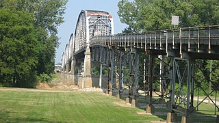
English: Southern side of the eastern end of the Harmony Way Bridge, which carries Indiana State Road 66 and Illinois Route 14 over the Wabash River between New Harmony, Indiana and rural White County, Illinois in the United States. Built in 1930, it is listed on the National Register of Historic Places. |
||
| Date | Taken on 3 September 2011 | ||
| Source | Own work | ||
| Author | Nyttend | ||
| Permission (Reusing this file) |
|
File history
Click on a date/time to view the file as it appeared at that time.
| Date/Time | Thumbnail | Dimensions | User | Comment | |
|---|---|---|---|---|---|
| current | 15:17, 10 September 2011 | | 2,816 × 1,584 (2.41 MB) | Nyttend | {{Location|38|7|48|N|87|56|24|W}} {{Information |Description={{en|Southern side of the eastern end of the {{w|New Harmony Toll Bridge|Harmony Way Bridge}}, which carries {{w|Indiana State Road 66}} and {{w|Illinois Route 14}} over the {{w|Wabash River}} b |
File usage
The following pages on the English Wikipedia use this file (pages on other projects are not listed):
Global file usage
The following other wikis use this file:
- Usage on de.wikipedia.org
- Usage on www.wikidata.org