
File:Hanstholmen-map.png

Original file (2,260 × 1,557 pixels, file size: 1.14 MB, MIME type: image/png)
| This is a file from the Wikimedia Commons. Information from its description page there is shown below. Commons is a freely licensed media file repository. You can help. |
Summary
Source: http://en.wikipedia.org/wiki/Image:Hanstholmen-map.png
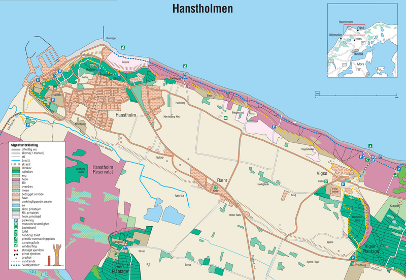
A detailed map of Hanstholm. From the brochure "Vandreture nr. 118. Hanstholmen", updated January 2005, published by the Danish Forest and Nature Agency. The dashed lines indicate a very steep slope, the former coastline.
Licensing
Under the case number "J.nr. SN 2001-0650-0003", where Lars Dybdahl requested permission to use this map with Wikipedia, the case was handled by the responsible person Pia Bøttiger Andersen from the Danish Ministry of the Environment, on the date 2005-12-20. The response was, that the Danish Forest and Nature Agency has permitted the use of this map for general use, as long as a reference to the source is given. This is an example of such a reference is in Danish:
- Fra Skov- og Naturstyrelsens folder "Vandreture nr. 118. Hanstholmen (opdateret januar 2005).
This translates into:
- From the Danish Forest and Nature Agency brochure "Vandreture nr. 118. Hanstholmen" (updated January 2005)
The official homepage of the agency is: www.skovognatur.dk Official email address of the agency is: sns@sns.dk
- You are free:
- to share – to copy, distribute and transmit the work
- to remix – to adapt the work
- Under the following conditions:
- attribution – You must give appropriate credit, provide a link to the license, and indicate if changes were made. You may do so in any reasonable manner, but not in any way that suggests the licensor endorses you or your use.
- share alike – If you remix, transform, or build upon the material, you must distribute your contributions under the same or compatible license as the original.
File history
Click on a date/time to view the file as it appeared at that time.
| Date/Time | Thumbnail | Dimensions | User | Comment | |
|---|---|---|---|---|---|
| current | 17:45, 27 June 2006 | | 2,260 × 1,557 (1.14 MB) | Igiveup | == Summary == Source: http://en.wikipedia.org/wiki/Image:Hanstholmen-map.png A detailed map of Hanstholm. From the brochure "Vandreture nr. 118. Hanstholmen", updated January 2005, published by [http://www.sns.dk/ the Danish Forest and Nature Agency]. T |
File usage
Global file usage
The following other wikis use this file: