
File:Hampi Vijayanagara in early 16th century, South India.jpg
Original file (1,292 × 1,122 pixels, file size: 277 KB, MIME type: image/jpeg)
| This is a file from the Wikimedia Commons. Information from its description page there is shown below. Commons is a freely licensed media file repository. You can help. |
Summary
| Description |
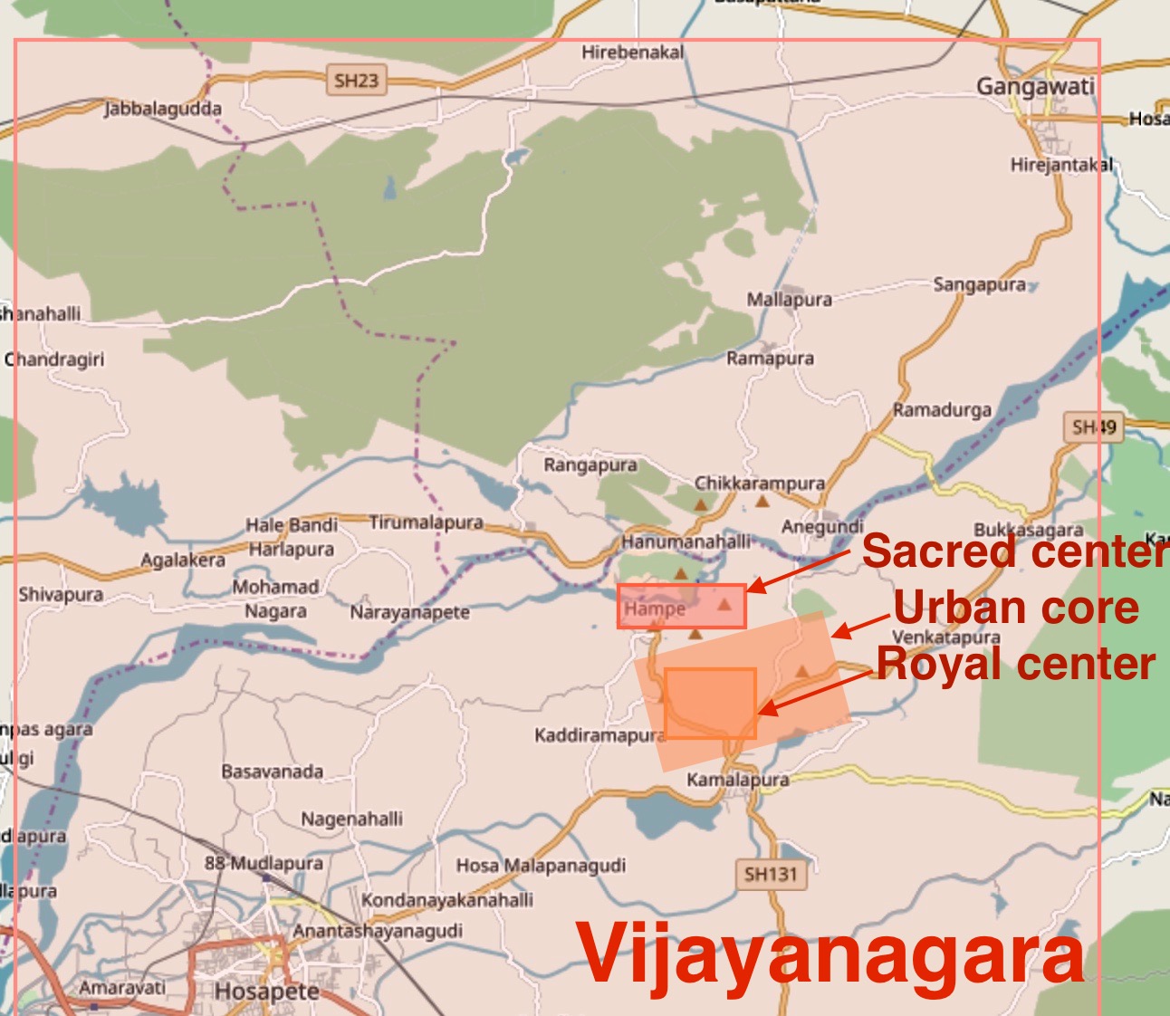
English: This is a derivative work on OpenStreet map available under Creative Commons 2.0 license, as downloaded on October 13 2017.
Source: http://www.openstreetmap.org/ Authors of the raw map: OpenStreetMap contributors Note: This map was created from OpenStreetMap project data, collected by the community. This map may be incomplete, and may contain errors. Don't rely solely on it for navigation or scholarship. The markings and other information are approximate. The image shows the Hampi sacred center, the urban core and royal center, as well as the spread of Vijayanagara metropolis suburbs around the urban core. Archaeological surveys and excavations have located Vijayanagara ruins from Gangawati in northeast to Hosapete in southwest. For example, the Anantashayana Gudi is found in Hosapete. Many residential areas were closer to the urban core. According to scholars, Vijayanagara was the second largest city in the world, after Beijing, in early 16th century. The city was destroyed in 1565 CE and most of it remained in ruins since then. |
| Date | |
| Source | Own work |
| Author | Ms Sarah Welch |
Licensing
- You are free:
- to share – to copy, distribute and transmit the work
- to remix – to adapt the work
- Under the following conditions:
- attribution – You must give appropriate credit, provide a link to the license, and indicate if changes were made. You may do so in any reasonable manner, but not in any way that suggests the licensor endorses you or your use.
- share alike – If you remix, transform, or build upon the material, you must distribute your contributions under the same or compatible license as the original.
File history
Click on a date/time to view the file as it appeared at that time.
| Date/Time | Thumbnail | Dimensions | User | Comment | |
|---|---|---|---|---|---|
| current | 21:55, 13 October 2017 | | 1,292 × 1,122 (277 KB) | Ms Sarah Welch | User created page with UploadWizard |
File usage
Global file usage
The following other wikis use this file: