
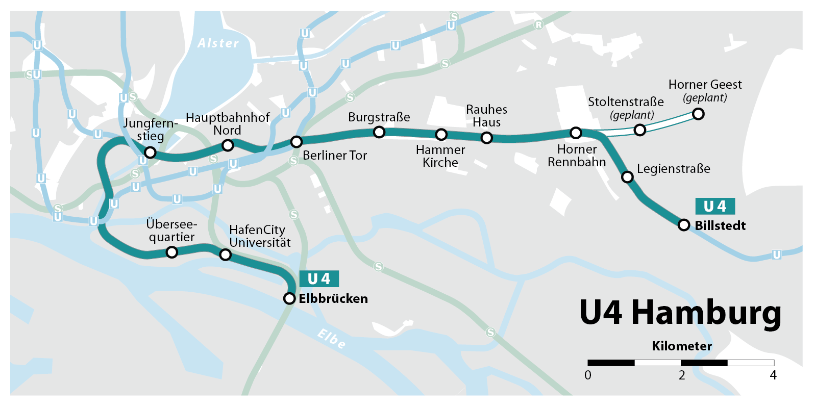
File:Hamburger Hochbahn - Plan der Linie U4.png
Size of this preview: 800 × 400 pixels. Other resolutions: 320 × 160 pixels | 640 × 320 pixels | 1,024 × 512 pixels | 1,595 × 798 pixels.
Original file (1,595 × 798 pixels, file size: 119 KB, MIME type: image/png)
| This is a file from the Wikimedia Commons. Information from its description page there is shown below. Commons is a freely licensed media file repository. You can help. |
| Description |
|
| Date | see file history |
| Source |
Self made, using the information from and using the following graphic: |
| Author | Maximilian Dörrbecker (Chumwa) |
| Permission (Reusing this file) |
I, the copyright holder of this work, hereby publish it under the following license: This file is licensed under the Creative Commons Attribution-Share Alike 2.5 Generic license.
Sie dürfen das Bild zu den folgenden Bedingungen nutzen:
|
| Other versions |
|

.png)


File history
Click on a date/time to view the file as it appeared at that time.
| Date/Time | Thumbnail | Dimensions | User | Comment | |
|---|---|---|---|---|---|
| current | 16:43, 29 June 2021 | | 1,595 × 798 (119 KB) | NordNordWest | corr |
| 07:25, 4 December 2018 |  | 1,595 × 798 (191 KB) | Chumwa | Eröffnung der Station Elbbrücken | |
| 16:19, 3 August 2017 |  | 1,595 × 798 (195 KB) | Chumwa | Horner Geest -> Dannerallee | |
| 20:39, 13 January 2016 |  | 1,595 × 798 (193 KB) | Flor!an | Reverted to version as of 05:42, 26 March 2015 (UTC) Olympiastadion ist nicht mehr geplant | |
| 10:23, 24 August 2015 |  | 1,595 × 798 (207 KB) | Behördenopfer | Haltestelle 'Kleiner Grasbrook' wieder rein, inzwischen offizielle Planung. Quelle: http://www.nahverkehrhamburg.de/u-bahn-hamburg/item/1510-das-ist-die-u4-verlaengerung-ueber-die-elbe | |
| 05:42, 26 March 2015 |  | 1,595 × 798 (193 KB) | Chumwa | Olympiastadion raus, da nur Spekulation; Stoltenstraße und Horner Geest eingetragen, da offizielle Planungsnamen | |
| 18:11, 19 November 2014 |  | 1,595 × 798 (212 KB) | Behördenopfer | Neueste Planungen hinzugefügt: Verlängerungen Horner Geest, Olympiastadion. | |
| 18:11, 19 November 2014 |  | 1,595 × 798 (212 KB) | Behördenopfer | Neueste Planungen hinzugefügt: Verlängerungen Horner Geest, Olympastadion. | |
| 06:05, 13 April 2013 |  | 1,595 × 798 (182 KB) | Chumwa | +Elbbrücken | |
| 21:42, 30 July 2012 |  | 1,595 × 798 (176 KB) | Chumwa | Linienfarbe angepasst |
File usage
No pages on the English Wikipedia use this file (pages on other projects are not listed).
Global file usage
The following other wikis use this file:
- Usage on ca.wikipedia.org
- Usage on de.wikipedia.org
- Usage on nl.wikipedia.org