
File:Haiti January 12, 2010 quake and Enriquillo-Plaintain Garden Fault.png
Size of this preview: 800 × 554 pixels. Other resolutions: 320 × 221 pixels | 640 × 443 pixels | 1,024 × 709 pixels | 1,280 × 886 pixels | 2,270 × 1,571 pixels.
Original file (2,270 × 1,571 pixels, file size: 2.5 MB, MIME type: image/png)
| This is a file from the Wikimedia Commons. Information from its description page there is shown below. Commons is a freely licensed media file repository. You can help. |
| Description |
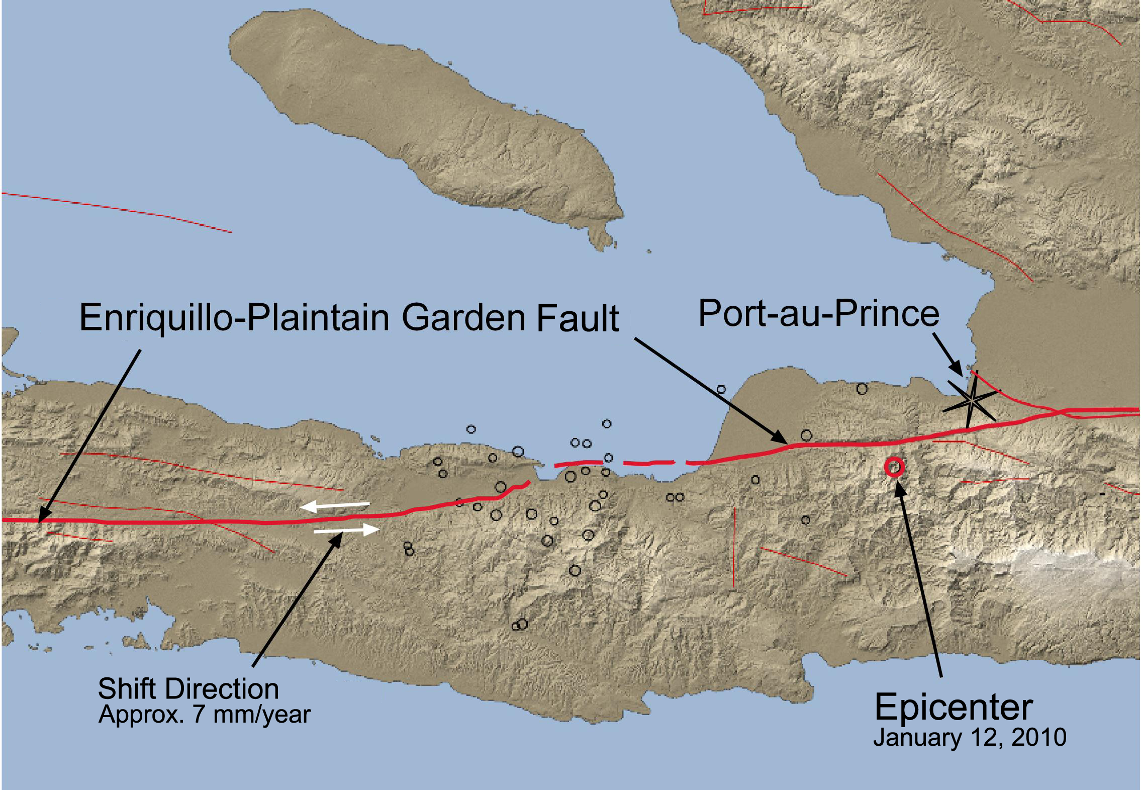
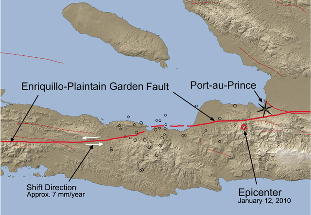
English: simpified tectonic map, showing the epicenter of the January 12, 2010 quake and the Enriquillo-Plaintain Garden Fault. Note the epicenter shown here is to the east of the coordinates given by USGS (18.457°N, 72.533°W), this image is probably in error. |
| Date | (UTC) |
| Source | |
| Author |
|
| This is a retouched picture, which means that it has been digitally altered from its original version. Modifications: English translation. The original can be viewed here: Haiti Erdbeben 120110.jpg:
|
I, the copyright holder of this work, hereby publish it under the following license:
This file is licensed under the Creative Commons Attribution-Share Alike 3.0 Unported license.
- You are free:
- to share – to copy, distribute and transmit the work
- to remix – to adapt the work
- Under the following conditions:
- attribution – You must give appropriate credit, provide a link to the license, and indicate if changes were made. You may do so in any reasonable manner, but not in any way that suggests the licensor endorses you or your use.
- share alike – If you remix, transform, or build upon the material, you must distribute your contributions under the same or compatible license as the original.
Original upload log
This image is a derivative work of the following images:
- File:Haiti_Erdbeben_120110.jpg licensed with Cc-by-sa-3.0
- 2010-01-18T11:31:59Z Amphibol 2270x1571 (457435 Bytes) Bewegungsrichtung und -stärke der Verwerfung eingezeichnez
- 2010-01-14T13:53:53Z Amphibol 2270x1571 (442451 Bytes) == Beschreibung == {{Information |Description={{de|Vereinfachte tektonische Karte der Region um Port-au-Prince mit dem Epizentrum des Erdbebens vom 12. Januar 2010 (roter Kreis) sowie den Epizentren mehrerer Nachbeben (schwar
Uploaded with derivativeFX
File history
Click on a date/time to view the file as it appeared at that time.
| Date/Time | Thumbnail | Dimensions | User | Comment | |
|---|---|---|---|---|---|
| current | 14:44, 27 January 2010 | | 2,270 × 1,571 (2.5 MB) | Kmusser | {{Information |Description={{en|simpified tectonic map, schowing the epicenter of the January 12th quake and the Enriquillo-Plaintain Garden Fault}} |Source=*File:Haiti_Erdbeben_120110.jpg |Date=2010-01-27 14:43 (UTC) |Author=*[[:File:Haiti_Erdbeben |
File usage
The following pages on the English Wikipedia use this file (pages on other projects are not listed):
Global file usage
The following other wikis use this file:
- Usage on nl.wikipedia.org
- Usage on pt.wikipedia.org
- Usage on ru.wikipedia.org
- Usage on uk.wikipedia.org