
File:HUNTINGTON 1868 Survey Rancho Cienega o Paso de la Tijera.jpg

Original file (2,420 × 2,420 pixels, file size: 1.06 MB, MIME type: image/jpeg)
| This is a file from the Wikimedia Commons. Information from its description page there is shown below. Commons is a freely licensed media file repository. You can help. |
Summary
| Description |
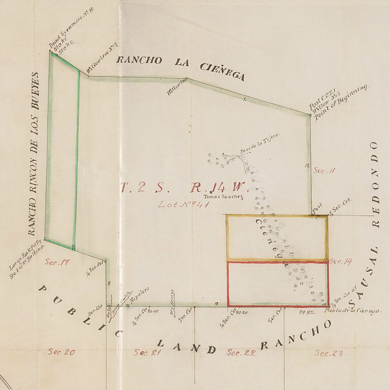
English: HUNTINGTON 1868 Survey Rancho Cienega o Paso de la Tijera |
| Date | |
| Source |
Title Plat of the Rancho Cienega o Paso de la Tijera confirmed to Tomas Sanchez. Alt Title Rancho la Ciénega ó Paso de la Tijera: S77 : plat of the Rancho Cienega o Paso de la Tijera confirmed to Tomas Sanchez. Creator Thompson, George H. Date Searchable 1868-07 Date 1868 July Call Number SR_Box_21(02).02 Physical Description 1 ms. map ; 7 x 8 in., on sheet 17 1/4 x 20 in., ink on tracing cloth Scale 1 : 40 chains Location depicted Cienega o Paso de la Tijera, Rancho View Park Windsor Hills Description Bordering Ranchos Rincon de los Bueyes, Sausal Redondo, La Cienega and public lands. Bound within document: "In the District Court of the Seventeenth... Bertrand Riviere vs. T.A. Sanchez et al..." with color highlighting, surface details, section & lot numbers, markers; certified by numerous officials, with table of boundary data. Alt. title supplied by cataloger. Subjects Baldwin Hills (Los Angeles, Calif.) California -- History -- 1850-1950. Historical maps. (aat) Los Angeles County (Calif.) -- Maps. Sánchez, Tomás A., 1826-1882. Ranches -- California, Southern -- Maps. Surveying -- California, Southern -- History. Physical Collection Solano-Reeve collection Rights For information on use of Digital Library materials, please see Library Rights and Permissions: https://www.huntington.org/library-rights-permissions Digital Collection Maps, Huntington Digital Library Digitization Specifications High Res Unique Digital Identifier 313842 IIIF Manifest https://hdl.huntington.org/iiif/info/p15150coll4/12358/manifest.json IIIF Image https://hdl.huntington.org/digital/iiif/p15150coll4/12358/full/full/0/default.jpg |
| Author | GLO/BLM |
Licensing
This work is in the public domain in the United States because it was published (or registered with the U.S. Copyright Office) before January 1, 1929.
Public domain works must be out of copyright in both the United States and in the source country of the work in order to be hosted on the Commons. If the work is not a U.S. work, the file must have an additional copyright tag indicating the copyright status in the source country.
Note: This tag should not be used for sound recordings. |
File history
Click on a date/time to view the file as it appeared at that time.
| Date/Time | Thumbnail | Dimensions | User | Comment | |
|---|---|---|---|---|---|
| current | 21:01, 31 March 2023 | | 2,420 × 2,420 (1.06 MB) | Jengod | Uploaded a work by GLO/BLM from Title Plat of the Rancho Cienega o Paso de la Tijera confirmed to Tomas Sanchez. Alt Title Rancho la Ciénega ó Paso de la Tijera: S77 : plat of the Rancho Cienega o Paso de la Tijera confirmed to Tomas Sanchez. Creator Thompson, George H. Date Searchable 1868-07 Date 1868 July Call Number SR_Box_21(02).02 Physical Description 1 ms. map ; 7 x 8 in., on sheet 17 1/4 x 20 in., ink on tracing cloth Scale 1 : 40 chains Location depicted Cienega o Paso de la Tijera,... |