
File:Guaicuras.png

Size of this preview: 457 × 599 pixels. Other resolutions: 183 × 240 pixels | 366 × 480 pixels | 687 × 901 pixels.
Original file (687 × 901 pixels, file size: 791 KB, MIME type: image/png)
| This is a file from the Wikimedia Commons. Information from its description page there is shown below. Commons is a freely licensed media file repository. You can help. |
| Description |
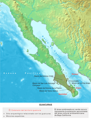
Español: Mapa del territorio guaicura, en la península de California (México) |
||
| Date | |||
| Source | Trabajo realizados sobre los mapas de demis.nl Image:Topographic30deg N0W90.png y Image:Topographic30deg N30W90.png, con información de Miguel León Portilla (2003): "Historia y formas de vida en Baja California"; Fermín Reygadas (2003): "Historia de la arqueología de la península de Baja California"; y Julia Bendímez (2003): "Las misiones de la península de Baja California"; en Arqueología Mexicana, 62:17-23, 32-39, 62-67. | ||
| Author | Yavidaxiu | ||
| Permission (Reusing this file) |
|
File history
Click on a date/time to view the file as it appeared at that time.
| Date/Time | Thumbnail | Dimensions | User | Comment | |
|---|---|---|---|---|---|
| current | 15:19, 7 December 2006 | | 687 × 901 (791 KB) | Yavidaxiu | {{Information |Description={{es|Mapa del territorio guaicura, en la península de California (México)}} |Source=Trabajo propio |Date=4 de noviembre de 2006 |Author=Yavidaxiu |Permission={{PD-self}} |other_versions= }} Category:Maps of Mexico |
File usage
The following pages on the English Wikipedia use this file (pages on other projects are not listed):
Global file usage
The following other wikis use this file:
- Usage on ast.wikipedia.org
- Usage on ca.wikipedia.org
- Usage on es.wikipedia.org
- Usage on gl.wikipedia.org
- Usage on ru.wikipedia.org
- Usage on www.wikidata.org