
File:Grosses Moor Karte 1780.jpg

Size of this preview: 449 × 599 pixels. Other resolutions: 180 × 240 pixels | 359 × 480 pixels | 776 × 1,036 pixels.
Original file (776 × 1,036 pixels, file size: 199 KB, MIME type: image/jpeg)
| This is a file from the Wikimedia Commons. Information from its description page there is shown below. Commons is a freely licensed media file repository. You can help. |
Summary
| Description |
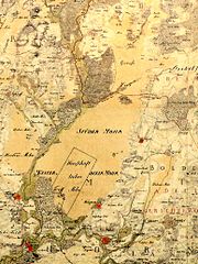
Deutsch: Grosses Moor Gifhorn Karte 1780 aus der kurhannoverschen Landesaufnahme 1779/1780. Mit den Orten rund um das Moor von links nach rechts: Kästorf, Gifhorn, Dannenbüttel , Westerbeck, Stüde |
| Date | |
| Source | Unknown source |
| Author | Unbekannt, hochgeladen von AxelHH |
Licensing
|
This work is in the public domain in its country of origin and other countries and areas where the copyright term is the author's life plus 100 years or fewer. | |
| This file has been identified as being free of known restrictions under copyright law, including all related and neighboring rights. | |
File history
Click on a date/time to view the file as it appeared at that time.
| Date/Time | Thumbnail | Dimensions | User | Comment | |
|---|---|---|---|---|---|
| current | 00:10, 29 January 2014 | | 776 × 1,036 (199 KB) | Agp | Kontrast optimiert |
| 22:34, 7 April 2012 |  | 776 × 1,036 (838 KB) | AxelHH | {{Information |Description ={{de|1=Grosses Moor Gifhorn Karte 1780}} |Source ={{own}} |Author =AxelHH |Date =1780 |Permission = |other_versions = }} Category:Grosses Moor Gifhorn |
File usage
The following pages on the English Wikipedia use this file (pages on other projects are not listed):
Global file usage
The following other wikis use this file:
- Usage on de.wikipedia.org