
File:Greenland ice sheet AMSL thickness map-en.png

Size of this preview: 351 × 599 pixels. Other resolutions: 141 × 240 pixels | 281 × 480 pixels | 450 × 768 pixels | 1,056 × 1,801 pixels.
Original file (1,056 × 1,801 pixels, file size: 1 MB, MIME type: image/png)
| This is a file from the Wikimedia Commons. Information from its description page there is shown below. Commons is a freely licensed media file repository. You can help. |
Summary
| Description |
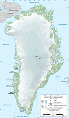
English: Map in English of Greenland ice sheet thickness. Thickness over 10 m above bedrock and mean sea level.
Français : Carte en anglais de l'épaisseur de l'inlandsis du Groenland. Épaisseur supérieure à 10 m au-dessus de la surface rocheuse et du niveau moyen des mers.
|
||
| Date | |||
| Source |
Own work
|
||
| Author | Eric Gaba (Sting - fr:Sting) | ||
| Permission (Reusing this file) |
|
||
| Other versions |
[]
|


| Camera location | | View this and other nearby images on: OpenStreetMap |
|---|
Licensing
Eric Gaba (Wikimedia Commons user Sting), the copyright holder of this work, hereby publishes it under the following license:
This file is licensed under the Creative Commons Attribution-Share Alike 3.0 Unported license.
Attribution: Eric Gaba (Wikimedia Commons user Sting)
- You are free:
- to share – to copy, distribute and transmit the work
- to remix – to adapt the work
- Under the following conditions:
- attribution – You must give appropriate credit, provide a link to the license, and indicate if changes were made. You may do so in any reasonable manner, but not in any way that suggests the licensor endorses you or your use.
- share alike – If you remix, transform, or build upon the material, you must distribute your contributions under the same or compatible license as the original.
File history
Click on a date/time to view the file as it appeared at that time.
| Date/Time | Thumbnail | Dimensions | User | Comment | |
|---|---|---|---|---|---|
| current | 20:12, 13 February 2011 | | 1,056 × 1,801 (1 MB) | Ras67 | cropped |
| 18:56, 3 January 2011 |  | 1,060 × 1,805 (1.17 MB) | Sting | == {{int:filedesc}} == {{Information |Description={{en|Map in English of Greenland ice sheet thickness. Thickness over 10 m above bedrock and mean sea level.}} {{fr|Carte en anglais de l'épaisseur de l'[[:fr:Inlandsis du Groen |
File usage
The following pages on the English Wikipedia use this file (pages on other projects are not listed):
Global file usage
The following other wikis use this file:
- Usage on ar.wikipedia.org
- Usage on ast.wikipedia.org
- Usage on az.wikipedia.org
- Usage on be-tarask.wikipedia.org
- Usage on be.wikipedia.org
- Usage on bn.wikipedia.org
- Usage on ca.wikipedia.org
- Usage on cs.wikipedia.org
- Usage on da.wikipedia.org
- Usage on es.wikipedia.org
- Usage on fr.wikipedia.org
- Usage on gl.wikipedia.org
- Usage on he.wikipedia.org
- Usage on hu.wikipedia.org
- Usage on hy.wikipedia.org
- Usage on id.wikipedia.org
- Usage on it.wikipedia.org
- Usage on ja.wikipedia.org
- Usage on ka.wikipedia.org
- Usage on ms.wikipedia.org
- Usage on nl.wikipedia.org
- Usage on pl.wikipedia.org
- Usage on ru.wikipedia.org
- Usage on sd.wikipedia.org
- Usage on to.wikipedia.org
- Usage on uk.wikipedia.org
- Usage on uz.wikipedia.org
- Usage on www.wikidata.org
- Usage on xmf.wikipedia.org