
File:Greater Manchester Railways without Metrolink.svg

Size of this PNG preview of this SVG file: 800 × 586 pixels. Other resolutions: 320 × 234 pixels | 640 × 469 pixels | 1,024 × 750 pixels | 1,280 × 938 pixels | 2,560 × 1,876 pixels | 913 × 669 pixels.
Original file (SVG file, nominally 913 × 669 pixels, file size: 116 KB)
| This is a file from the Wikimedia Commons. Information from its description page there is shown below. Commons is a freely licensed media file repository. You can help. |
Summary
| Description |
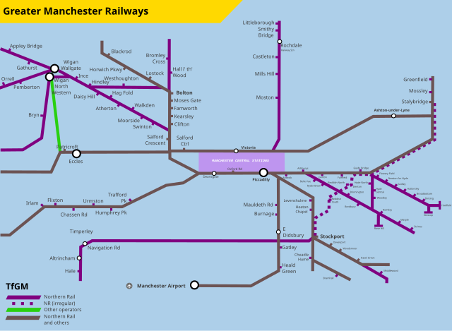
English: Map showing heavy rail services in Greater Manchester. Self-made using information obtained from the TfGM website and other maps uploaded to Wikimedia Commons. |
| Date | |
| Source | Own work |
| Author | RaviC |
| SVG development |
Licensing
I, the copyright holder of this work, hereby publish it under the following license:
This file is licensed under the Creative Commons Attribution-Share Alike 4.0 International license.
- You are free:
- to share – to copy, distribute and transmit the work
- to remix – to adapt the work
- Under the following conditions:
- attribution – You must give appropriate credit, provide a link to the license, and indicate if changes were made. You may do so in any reasonable manner, but not in any way that suggests the licensor endorses you or your use.
- share alike – If you remix, transform, or build upon the material, you must distribute your contributions under the same or compatible license as the original.
File history
Click on a date/time to view the file as it appeared at that time.
| Date/Time | Thumbnail | Dimensions | User | Comment | |
|---|---|---|---|---|---|
| current | 16:48, 6 March 2019 | | 913 × 669 (116 KB) | RaviC | + MCR Central stns, fixes |
| 17:11, 17 February 2019 |  | 913 × 669 (117 KB) | RaviC | User created page with UploadWizard |
File usage
The following pages on the English Wikipedia use this file (pages on other projects are not listed):