
File:Gonu 2007-06-04 0900Z.jpg

Size of this preview: 450 × 600 pixels. Other resolutions: 180 × 240 pixels | 360 × 480 pixels | 576 × 768 pixels | 768 × 1,024 pixels | 1,536 × 2,048 pixels | 5,550 × 7,400 pixels.
Original file (5,550 × 7,400 pixels, file size: 9.84 MB, MIME type: image/jpeg)
| This is a file from the Wikimedia Commons. Information from its description page there is shown below. Commons is a freely licensed media file repository. You can help. |
Summary
| Description |
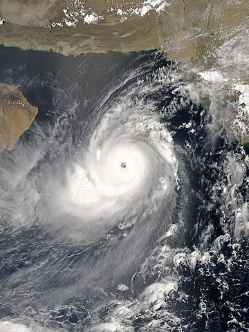
English: The Aqua satellite acquired the picture of Gonu, the most intense tropical cyclone of the Arabian Sea on record, at 12:00 Arabia Standard Time (09:00 UTC) on 4 June 2007. Although the India Meteorological Department claimed that Gonu intensified into a super cyclonic storm at 15:00 UTC, the Joint Typhoon Warning Center indicated that Gonu had started to weaken since 12:00 UTC. Based on the appearance, the picture should be at peak intensity in reality. |
| Date | |
| Source | NASA Earth Observatory |
| Author | MODIS image captured by NASA’s Aqua satellite |
| Camera location | | View this and other nearby images on: OpenStreetMap |
|---|
Licensing
| This file is in the public domain in the United States because it was solely created by NASA. NASA copyright policy states that "NASA material is not protected by copyright unless noted". (See Template:PD-USGov, NASA copyright policy page or JPL Image Use Policy.) | ||
 |
Warnings:
|
File history
Click on a date/time to view the file as it appeared at that time.
| Date/Time | Thumbnail | Dimensions | User | Comment | |
|---|---|---|---|---|---|
| current | 10:05, 27 October 2016 | | 5,550 × 7,400 (9.84 MB) | Meow | Optimised from the original TIFF file under current standards. |
| 04:55, 15 November 2007 |  | 6,000 × 7,800 (7.7 MB) | Good kitty | == Summary == {{Information |Description=You might expect to see a storm with near-perfect symmetry and a well-defined eye hoovering over the warm waters of the Caribbean or in the South Pacific, but Tropical Cyclone Gonu showed up in an unusual place. On |
File usage
The following pages on the English Wikipedia use this file (pages on other projects are not listed):
- 2007 North Indian Ocean cyclone season
- Cyclone
- Cyclone Gonu
- List of Arabian Peninsula tropical cyclones
- List of the most intense tropical cyclones
- North Indian Ocean tropical cyclone
- Tropical cyclones in 2007
- Wikipedia:Featured picture candidates/June-2013
- Wikipedia:Featured picture candidates/Super Cyclonic Storm Gonu
- Wikipedia:Main Page history/2019 September 6
- Wikipedia:Today's featured article/June 2010
- Wikipedia:Today's featured article/June 3, 2010
- Wikipedia:Today's featured list/September 2019
- Wikipedia:Today's featured list/September 6, 2019
- Portal:Iran/Selected article/5
- Portal:Tropical cyclones
- Portal:Tropical cyclones/Anniversaries/June
- Portal:Tropical cyclones/Anniversaries/June/4
Global file usage
The following other wikis use this file:
- Usage on bn.wikipedia.org
- Usage on de.wikipedia.org
- Usage on es.wikipedia.org
- Usage on fa.wikipedia.org
- Usage on fr.wikipedia.org
- Usage on id.wikipedia.org
- Usage on ko.wikipedia.org
- Usage on nl.wikipedia.org
- Usage on pt.wikipedia.org
- Usage on uk.wikipedia.org
- Usage on vi.wikipedia.org
- Usage on zh.wikipedia.org