
File:Ghana Regions map.png

Size of this preview: 401 × 599 pixels. Other resolutions: 161 × 240 pixels | 321 × 480 pixels | 514 × 768 pixels | 685 × 1,024 pixels | 1,495 × 2,233 pixels.
Original file (1,495 × 2,233 pixels, file size: 1.03 MB, MIME type: image/png)
| This is a file from the Wikimedia Commons. Information from its description page there is shown below. Commons is a freely licensed media file repository. You can help. |
Summary
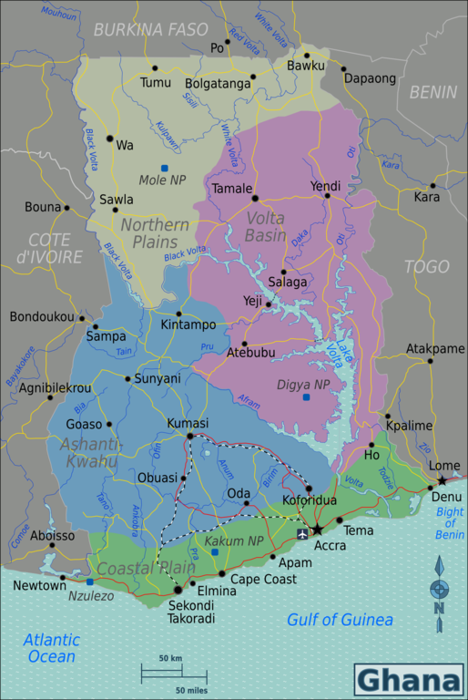
| Description | Map of Ghana for use on Wikivoyage, English version |
| Date | |
| Source | Own work based on Perry-Castañeda Library Map Collection Ghana Maps |
| Author | Burmesedays, minor amendments by Joelf |
| Other versions |
.png)
.png)
Licensing
This file is licensed under the Creative Commons Attribution-Share Alike 3.0 Unported license.
- You are free:
- to share – to copy, distribute and transmit the work
- to remix – to adapt the work
- Under the following conditions:
- attribution – You must give appropriate credit, provide a link to the license, and indicate if changes were made. You may do so in any reasonable manner, but not in any way that suggests the licensor endorses you or your use.
- share alike – If you remix, transform, or build upon the material, you must distribute your contributions under the same or compatible license as the original.
Original upload log
| This file was imported from Wikivoyage WTS. |
The original description page was here. All following user names refer to wts.wikivoyage-old.
- 2010-02-02 09:09 (WT-shared) Burmesedays[dead link] 1500×2241 (1063131 bytes) {{Imagecredit|credit=[[user:burmesedays]], [http://www.lib.utexas.edu/maps/Ghana.html Perry-Castañeda Library Map Collection Ghana Maps]|ca (Import from wikitravel.org/shared)
- 2010-04-25 08:44 (WT-shared) Burmesedays[dead link] 1500×2241 (1085999 bytes) (Import from wikitravel.org/shared)
- 2012-03-05 00:52 (WT-shared) Joelf[dead link] 1495×2233 (1082693 bytes) Fixed minor misspellings (Import from wikitravel.org/shared)
File history
Click on a date/time to view the file as it appeared at that time.
| Date/Time | Thumbnail | Dimensions | User | Comment | |
|---|---|---|---|---|---|
| current | 15:32, 23 November 2012 | | 1,495 × 2,233 (1.03 MB) | OgreBot | (BOT): Reverting to most recent version before archival |
| 15:32, 23 November 2012 |  | 1,500 × 2,241 (1.04 MB) | OgreBot | (BOT): Uploading old version of file from wts.wikivoyage-old; originally uploaded on 2010-04-25 08:44:25 by (WT-shared) Burmesedays | |
| 15:32, 23 November 2012 |  | 1,500 × 2,241 (1.01 MB) | OgreBot | (BOT): Uploading old version of file from wts.wikivoyage-old; originally uploaded on 2010-02-02 09:09:17 by (WT-shared) Burmesedays | |
| 23:50, 17 November 2012 |  | 1,495 × 2,233 (1.03 MB) | MGA73bot2 | {{BotMoveToCommons|wts.oldwikivoyage|year={{subst:CURRENTYEAR}}|month={{subst:CURRENTMONTHNAME}}|day={{subst:CURRENTDAY}}}} == {{int:filedesc}} == {{Information |description=Map of Ghana. Map of Ghana, Ghana * Map of: Ghana¤ |date=February 2nd 2010 |s... |
File usage
The following pages on the English Wikipedia use this file (pages on other projects are not listed):
Global file usage
The following other wikis use this file:
- Usage on bn.wikipedia.org
- Usage on de.wikivoyage.org
- Usage on en.wikivoyage.org
- Usage on es.wikipedia.org
- Usage on fa.wikipedia.org
- Usage on gpe.wikipedia.org
- Usage on gu.wikipedia.org
- Usage on he.wikivoyage.org
- Usage on incubator.wikimedia.org
- Usage on it.wikivoyage.org
- Usage on ja.wikivoyage.org
- Usage on ku.wikipedia.org
- Usage on si.wikipedia.org
- Usage on uk.wikivoyage.org
- Usage on vi.wikivoyage.org
- Usage on zh.wikivoyage.org