
File:Gerichtsherrschaften Landvogtei Thurgau.png
Size of this preview: 800 × 532 pixels. Other resolutions: 320 × 213 pixels | 640 × 425 pixels | 1,024 × 681 pixels | 1,280 × 851 pixels | 2,500 × 1,662 pixels.
Original file (2,500 × 1,662 pixels, file size: 985 KB, MIME type: image/png)
| This is a file from the Wikimedia Commons. Information from its description page there is shown below. Commons is a freely licensed media file repository. You can help. |
Summary
| Description |
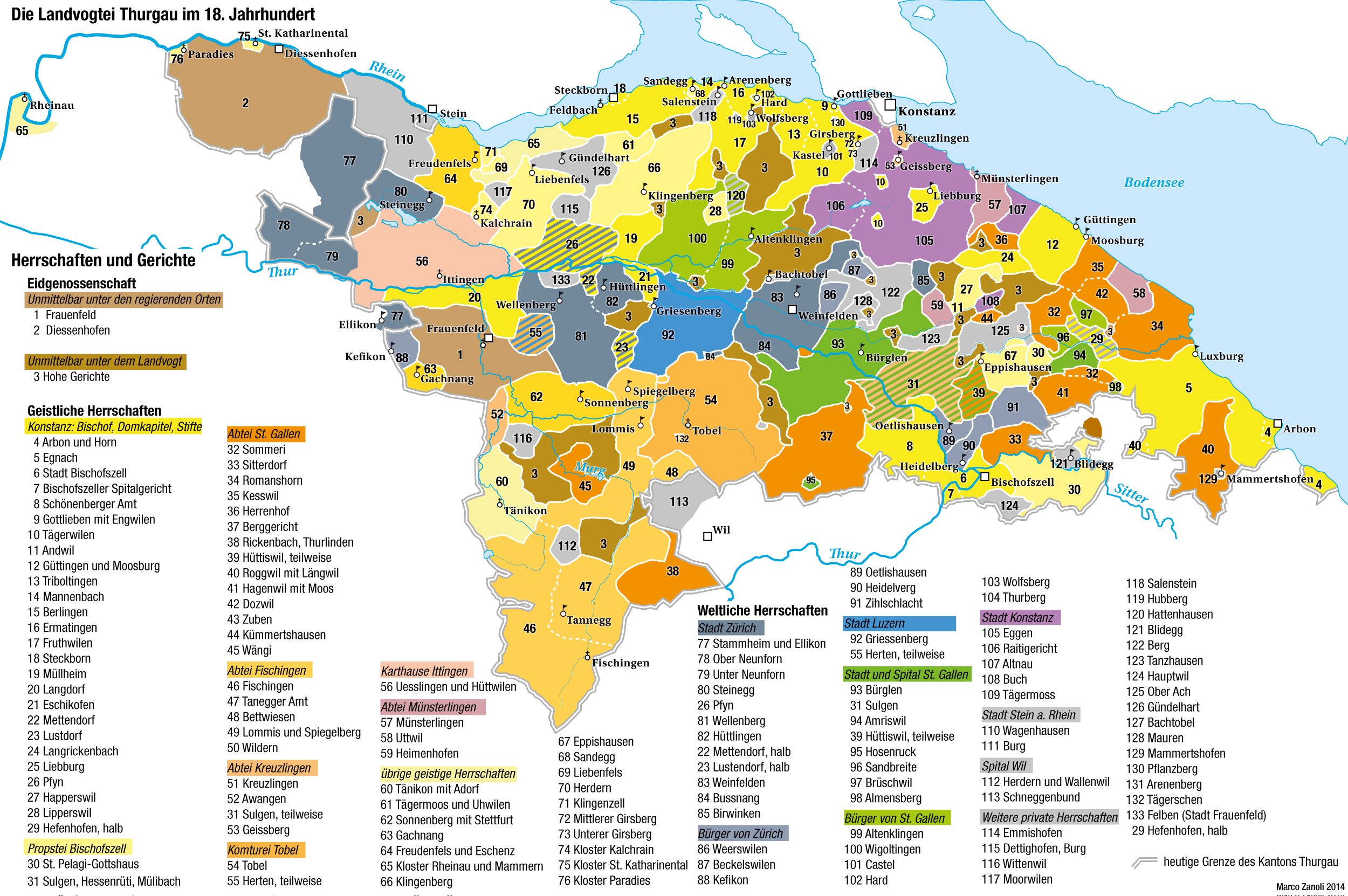
Deutsch: Herrschaften und Gerichtsherrschaften in der Landvogtei Thurgau in der Mitte des 18. Jahrhunderts. Nach Pupikofer 1861. |
|
| Date | ||
| Source | Own work | |
| Author | Marco Zanoli (Sidonius) | |
| Permission (Reusing this file) |
|
|
| Other versions | https://de.wikipedia.org/wiki/Datei:Lgt2.jpg |
Licensing
I, the copyright holder of this work, hereby publish it under the following license:
This file is licensed under the Creative Commons Attribution-Share Alike 3.0 Unported license.
- You are free:
- to share – to copy, distribute and transmit the work
- to remix – to adapt the work
- Under the following conditions:
- attribution – You must give appropriate credit, provide a link to the license, and indicate if changes were made. You may do so in any reasonable manner, but not in any way that suggests the licensor endorses you or your use.
- share alike – If you remix, transform, or build upon the material, you must distribute your contributions under the same or compatible license as the original.
File history
Click on a date/time to view the file as it appeared at that time.
| Date/Time | Thumbnail | Dimensions | User | Comment | |
|---|---|---|---|---|---|
| current | 07:43, 24 August 2020 | | 2,500 × 1,662 (985 KB) | Sidonius | kleine Korrektur: Felben, dank an Meinrad Suter |
| 16:41, 29 February 2020 |  | 2,500 × 1,662 (983 KB) | Sidonius | zahlreiche kleinere Fehler in Legende und Beschriftung behoben, dank an Angelus Hux | |
| 11:17, 26 August 2018 |  | 2,500 × 1,662 (885 KB) | Sidonius | Fehler korrigiert (Pfyn), Kantonsgrenze anders eingefärbt | |
| 20:28, 27 October 2014 |  | 2,500 × 1,662 (863 KB) | Sidonius | {{Information |Description ={{de|1=Herrschaften und Gerichtsherrschaften in der Landvogtei Thurgau in der Mitte des 18. Jahrhunderts. Nach Pupikofer 1861.}} |Source ={{own}} |Author =Marco Zanoli (Sidonius) |Date... |
File usage
The following pages on the English Wikipedia use this file (pages on other projects are not listed):
Global file usage
The following other wikis use this file:
- Usage on de.wikipedia.org
- Usage on fr.wikipedia.org
- Usage on nl.wikipedia.org