
File:Geologic map of Guam (cropped).jpg

Size of this preview: 468 × 599 pixels. Other resolutions: 187 × 240 pixels | 375 × 480 pixels | 600 × 768 pixels | 800 × 1,024 pixels | 1,600 × 2,048 pixels | 4,393 × 5,621 pixels.
Original file (4,393 × 5,621 pixels, file size: 1.66 MB, MIME type: image/jpeg)
| This is a file from the Wikimedia Commons. Information from its description page there is shown below. Commons is a freely licensed media file repository. You can help. |
Summary
| Description |
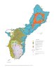
English: Map of the geology of Guam with geologic strata, fault lines, and major roads. Cross-sections corresponding to lines at File:Cross-sections of geology map of Guam (cropped).jpg. |
| Date | |
| Source | https://pubs.usgs.gov/wri/wri034126/pdf/fig02a.pdf. Used in USGS Water-Resources Investigation Report 03-4126, Honolulu, Hawaii 2003 (https://pubs.usgs.gov/wri/wri034126/htdocs/wrir03-4126.html) |
| Author | Stephen B. Gingerich, U.S. Geological Survey |
| Other versions |
.jpg)
.jpg)
Licensing
This image is in the public domain in the United States because it only contains materials that originally came from the United States Geological Survey, an agency of the United States Department of the Interior. For more information, see the official USGS copyright policy.
|
File history
Click on a date/time to view the file as it appeared at that time.
| Date/Time | Thumbnail | Dimensions | User | Comment | |
|---|---|---|---|---|---|
| current | 22:21, 13 March 2021 | | 4,393 × 5,621 (1.66 MB) | Featous | File:Geologic map of Guam.pdf cropped 14 % horizontally, 15 % vertically using CropTool with lossless mode. |
File usage
The following pages on the English Wikipedia use this file (pages on other projects are not listed):
.jpg)